IMAGES TAKEN NEAR TO
Hatton, WARWICK, CV35 7HB
Introduction
This page details the photographs taken nearby to CV35 7HB by members of the Geograph project.
The Geograph project started in 2005 with the aim of publishing, organising and preserving representative images for every square kilometre of Great Britain, Ireland and the Isle of Man.

There are currently over 7.5m images from over14,400 individuals and you can help contribute to the project by visiting https://www.geograph.org.uk
Image Map
Images are licensed for reuse under creativecommons.org/licenses/by-sa/2.0
Notes
- Clicking on the map will re-center to the selected point.
- The higher the marker number, the further away the image location is from the centre of the postcode.
Image Listing (9 Images Found)
Images are licensed for reuse under creativecommons.org/licenses/by-sa/2.0
Image
Details
Distance
1
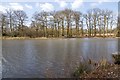
Shrewley Pools
A Quiet Sports Fishery. http://www.quietsports.co.uk/fisheries%20pdf/shrewley.html
Image: © David P Howard
Taken: 3 Apr 2013
0.07 miles
2
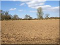
Field off driveway to Pool Farm
Looking NNE off the driveway and footpath to Pool Farm.
The field had recently been ploughed.
Image: © David P Howard
Taken: 3 Apr 2013
0.08 miles
3
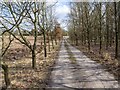
Driveway to Pool Farm
Looking ESE down the driveway to Pool Farm and Shrewley Pools which are both in Image
The driveway is also a footpath from Five Ways Road to Birmingham Road.
Image: © David P Howard
Taken: 3 Apr 2013
0.09 miles
4
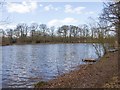
Shrewley Pools
A Quiet Sports Fishery. http://www.quietsports.co.uk/fisheries%20pdf/shrewley.html
Image: © David P Howard
Taken: 3 Apr 2013
0.09 miles
5
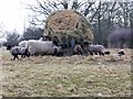
Sheep and lambs by the feeder
The sheep and lambs are getting a welcome supplement to their diet, after several weeks of unseasonably cold and snowy weather.
Image: © David P Howard
Taken: 3 Apr 2013
0.13 miles
6
Driveway to Piper's Cottage Farm
Driveway off Five Ways Road.
Image: © David P Howard
Taken: 3 Apr 2013
0.14 miles
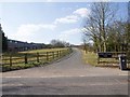
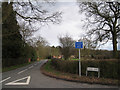
7
A4177 approaching Five Ways
Fast and busy, the A4177 is the former A41 Birmingham Road from Warwick to Birmingham via Knowle and Solihull. It was renumbered after the opening of the M40 Oxford-Birmingham motorway extension in 1990. It is crossed or joined by several public footpaths. Here, mercifully, visibility is good in both directions.
The former A41 south of Warwick was reclassified as the B4100 for most of its length to Banbury.
Image: © Robin Stott
Taken: 15 Mar 2010
0.17 miles
8
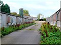
Stock Unit near Pool Farm
Just across the road from the large pond that gives Pool Farm its name is this stock rearing unit which may have been for pigs. It appeared to be disused.
Image: © Nigel Mykura
Taken: 9 Oct 2011
0.18 miles
9
Shaws Lane, Five Ways
Five Ways could be thought of as a detached suburb that has grown up south and west of the five-way road junction. Shaws Lane is less than 300 metres long but gives access to ten or so detached properties set here and there among the trees.
Image: © Robin Stott
Taken: 27 Mar 2010
0.24 miles