IMAGES TAKEN NEAR TO
Town Ground, WARWICK, CV35 0NN
Introduction
This page details the photographs taken nearby to Town Ground, CV35 0NN by members of the Geograph project.
The Geograph project started in 2005 with the aim of publishing, organising and preserving representative images for every square kilometre of Great Britain, Ireland and the Isle of Man.

There are currently over 7.5m images from over14,400 individuals and you can help contribute to the project by visiting https://www.geograph.org.uk
Image Map
Images are licensed for reuse under creativecommons.org/licenses/by-sa/2.0
Notes
- Clicking on the map will re-center to the selected point.
- The higher the marker number, the further away the image location is from the centre of the postcode.
Image Listing (21 Images Found)
Images are licensed for reuse under creativecommons.org/licenses/by-sa/2.0
Image
Details
Distance
1
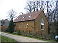
Old Wesleyan Chapel, Butlers Marston
This old chapel, just to the north of the green with the mill mound has now been converted into housing.
Image: © David Stowell
Taken: 2 Jan 2006
0.05 miles
2
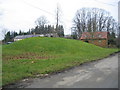
Mill Mound, Butlers Marston
Situated on the green in the village, this is marked on the OS Map as a "mill mound". Given its location presumably a windmill once sat on the top.
Image: © David Stowell
Taken: 2 Jan 2006
0.05 miles
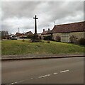
3
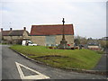
Butlers Marston
The village war memorial on the green in the middle of the village.
Image: © David Stowell
Taken: 2 Jan 2006
0.05 miles
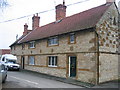
4
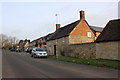
Bank Close Butlers Marston
This is the main street of the village and it does not lead anywhere except the village. The old buildings on the right are part of College Farm.
Image: © Nigel Mykura
Taken: 13 Mar 2018
0.08 miles
5
Butlers Marston old school
This old school building, in the "V" between the roads entering the village from the west, is currently being converted for residential use.
Image: © David Stowell
Taken: 2 Jan 2006
0.09 miles
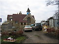
6
Row of cottages, Butlers Marston
This row of cottages is at the road junction on the west of the village, and near the northern edge of the square. They may not be as old as they first appear as a well work stone on the building behind the van bears the date 1913.
Image: © David Stowell
Taken: 2 Jan 2006
0.09 miles
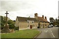
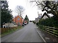
7

Life on a curve
This row of estate cottages follows the curve of the road in Butler's Marston and date from the early Edwardian period.
Image: © Colin Craig
Taken: 16 Sep 2009
0.09 miles
9
Village cross, Butler's Marston
The centre of this small village in Warwickshire.
Image: © Colin Craig
Taken: 16 Sep 2009
0.10 miles
10
Butlers Marston
Looking SW up the road into Butlers Marston from Little Kineton.
Image: © David P Howard
Taken: 31 Mar 2010
0.11 miles