IMAGES TAKEN NEAR TO
Green Farm End, WARWICK, CV35 0LD
Introduction
This page details the photographs taken nearby to Green Farm End, CV35 0LD by members of the Geograph project.
The Geograph project started in 2005 with the aim of publishing, organising and preserving representative images for every square kilometre of Great Britain, Ireland and the Isle of Man.

There are currently over 7.5m images from over14,400 individuals and you can help contribute to the project by visiting https://www.geograph.org.uk
Image Map
Images are licensed for reuse under creativecommons.org/licenses/by-sa/2.0
Notes
- Clicking on the map will re-center to the selected point.
- The higher the marker number, the further away the image location is from the centre of the postcode.
Image Listing (40 Images Found)
Images are licensed for reuse under creativecommons.org/licenses/by-sa/2.0
Image
Details
Distance
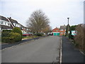
1
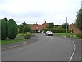
Shortacres, Kineton
Looking along Shortacres towards the junction with Green Farm End.
Image: © David P Howard
Taken: 19 Sep 2011
0.02 miles
2
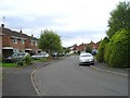
Shortacres, Kineton
Looking SSW down Shortacres.
Image: © David P Howard
Taken: 19 Sep 2011
0.02 miles
3
Green Farm End, Kineton
Looking east along Green Farm End, at the very NE edge of the village.
Image: © David P Howard
Taken: 19 Sep 2011
0.06 miles
4

Mill cottages?
This much altered row of cottages in Kineton looks like it was built to serve the adjacent mill in the town.
Image: © Colin Craig
Taken: 10 Apr 2011
0.09 miles
5

Former mill buildings
These former mill buildings in Kineton have been converted into offices and other uses.
Image: © Colin Craig
Taken: 10 Apr 2011
0.11 miles
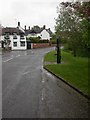
6
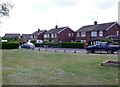
St Peters Rd
This small patch of green grass is at the junction of this circular road where it meets the Southam Rd out of Kineton. The road is mostly mdern semi-detached houses.
Image: © Nigel Mykura
Taken: 2 Jul 2011
0.12 miles
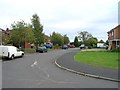
7
Shortacres, Kineton
Looking north at the western edge of this square. This modern development is on the eastern side of the village.
Image: © David Stowell
Taken: 2 Jan 2006
0.12 miles
8
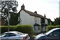
Last chance to see
By the time you view this picture the house it shows will probably be gone. This nice old farmhouse in Kineton has been surrounded by new housing and despite being converted to flats, was finally abandoned some years ago. According to local people at the time the pic was taken, the site is due for redevelopment by a housing association.
Image: © Colin Craig
Taken: 10 Apr 2011
0.14 miles
9
Kineton, village pump
Simple, cast-iron pump in Banbury Street; surprisingly, unchained, so it might still work.http://www.villagepumps.org.uk/kineton.htm
Image: © Mike Faherty
Taken: 27 Apr 2009
0.15 miles
10
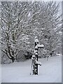
Kineton water pump
This 19th century cast iron water pump stands on the Banbury Road, near the junction with Mill Lane. It has two water spouts and one handle that operated both spouts. It was refurbished in the 1990s and is a Grade II listed structure, having been listed in 1999. See: https://historicengland.org.uk/listing/the-list/list-entry/1381879
Image: © Marika Reinholds
Taken: 6 Jan 2010
0.15 miles