
IMAGES TAKEN NEAR TO
Warwick Road, WARWICK, CV35 0HD
Introduction
This page details the photographs taken nearby to Warwick Road, CV35 0HD by members of the Geograph project.
The Geograph project started in 2005 with the aim of publishing, organising and preserving representative images for every square kilometre of Great Britain, Ireland and the Isle of Man.

There are currently over 7.5m images from over14,400 individuals and you can help contribute to the project by visiting https://www.geograph.org.uk
Image Map
Images are licensed for reuse under creativecommons.org/licenses/by-sa/2.0
Notes
- Clicking on the map will re-center to the selected point.
- The higher the marker number, the further away the image location is from the centre of the postcode.
Image Listing (44 Images Found)
Images are licensed for reuse under creativecommons.org/licenses/by-sa/2.0
Image
Details
Distance
1
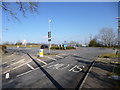
Gaydon, roundabout
At the junction of B4100 and B4413, seen from Kineton Road.
Image: © Mike Faherty
Taken: 17 Feb 2013
0.08 miles
2

Road closed
The old route of the B4100 has been permanently closed to vehicular traffic just north of Gaydon, due to the recent opening of a new section of dual carriageway from junction 12 of the M40.
Image: © David P Howard
Taken: 31 Aug 2016
0.10 miles
3
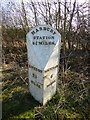
Old Milepost by the B4100, Banbury Road, Gaydon
Cast iron post by the B4100, in parish of GAYDON (STRATFORD ON AVON District), 150m North of junction island at Gaydon, Warwick to Banbury Road, on wide grass verge, close to informal lay-by; ditch and hedge behind, close to modern road sign, on East side of road. Southam iron casting, erected by an unknown authority in the 19th century.
Inscription reads:-
: KINETON / 2¾ / MILES. : : HARBURY / STATION / 3¾ MILES. : : SOUTHAM / 6 / MILES. :
Faint inscribed BM top centre and nick in rim.
Milestone Society National ID: WA_SHKN06.
Image: © Mike Faherty
Taken: Unknown
0.13 miles

5
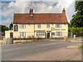
The Gaydon Inn
Currently closed, The Gaydon Inn stands at the junction of Banbury Road and Church Lane. The former coaching house, dating from the early 19th century, is said to have been notorious for its association with violent highwaymen (http://www.discover-stratford.com/Gaydon.cfm Discover Stratford).
The Gaydon Inn is a grade II listed building (English Heritage Building ID: 307057 http://www.britishlistedbuildings.co.uk/en-307057-gaydon-inn-gaydon-warwickshire#.VelzIXmFOHs British Listed Buildings).
Image: © David Dixon
Taken: 1 Sep 2015
0.18 miles
6
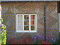
Village Hall, Gaydon
Wooden panelling makes for a very distinctive village amenity.
Image: © Michael Trolove
Taken: 9 Jun 2006
0.18 miles
7
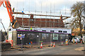
The former Gaydon Inn, now being redeveloped
Updates Image from 2015. The former Inn is being converted to a private house, as part of the redevelopment of the whole site into a small group of upmarket new homes.
See also Image from 2011 and Image from 2013. The main road in front of the inn has been reduced to single carriageway controlled by traffic lights, while rebuilding goes on.
Image: © Mike Dodman
Taken: 10 Nov 2016
0.19 miles
8
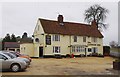
The Gaydon Inn (1), Banbury Road, Gaydon
Located on the B4100 road, this public house is Grade II listed. It was formerly a coaching inn, with a stable block. In the 18th century the inn was a notorious haunt of highwaymen.
Image
Image: © P L Chadwick
Taken: 9 Mar 2013
0.19 miles
9
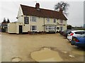
The Gaydon Inn
Public House on the eastern edge of the village.
Image: © Ian Rob
Taken: 21 Dec 2011
0.19 miles
10
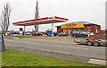
Esso Gaydon Otr Service Station, Banbury Road, Gaydon
This filling station on the B4100 road has an On the Run café and convenience store. It is opposite the Gaydon Inn.
Image: © P L Chadwick
Taken: 9 Mar 2013
0.20 miles