IMAGES TAKEN NEAR TO
Banbury Road, WARWICK, CV35 0DB
Introduction
This page details the photographs taken nearby to Banbury Road, CV35 0DB by members of the Geograph project.
The Geograph project started in 2005 with the aim of publishing, organising and preserving representative images for every square kilometre of Great Britain, Ireland and the Isle of Man.

There are currently over 7.5m images from over14,400 individuals and you can help contribute to the project by visiting https://www.geograph.org.uk
Image Map
Images are licensed for reuse under creativecommons.org/licenses/by-sa/2.0
Notes
- Clicking on the map will re-center to the selected point.
- The higher the marker number, the further away the image location is from the centre of the postcode.
Image Listing (4 Images Found)
Images are licensed for reuse under creativecommons.org/licenses/by-sa/2.0
Image
Details
Distance
1
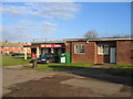
Lighthorne Heath Post Office and Stores
Lighthorne Heath was built to house the officers and men operating RAF Gaydon. Although the airfield has now closed and the village is now inhabited by civilians, the village buildings still retain their services appearance, as seen here at the village PO and stores.
Image: © David Stowell
Taken: 23 Dec 2005
0.10 miles
2
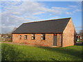
Village Hall, Lighthorne Heath
This modern building, along with the small sports field is adjacent to the Post Office and village stores in the SW quadrant of the square near the previous site of the entrance to Gaydon airfield itself.
Image: © David Stowell
Taken: 23 Dec 2005
0.10 miles
3
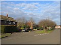
Marston Avenue, Lighthorne Heath
Looking NE along one of the main thoroughfares in this distinctively ex-services housing development.
Image: © David Stowell
Taken: 23 Dec 2005
0.12 miles
4
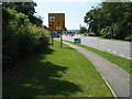
Road to Gaydon Vehicle Proving Ground
Too many security cameras looking out for any closer detail.
Image: © Michael Trolove
Taken: 8 Jun 2008
0.24 miles