IMAGES TAKEN NEAR TO
Spinney Close, Redlands Park, WARWICK, CV35 0AQ
Introduction
This page details the photographs taken nearby to Spinney Close, Redlands Park, CV35 0AQ by members of the Geograph project.
The Geograph project started in 2005 with the aim of publishing, organising and preserving representative images for every square kilometre of Great Britain, Ireland and the Isle of Man.

There are currently over 7.5m images from over14,400 individuals and you can help contribute to the project by visiting https://www.geograph.org.uk
Image Map
Images are licensed for reuse under creativecommons.org/licenses/by-sa/2.0
Notes
- Clicking on the map will re-center to the selected point.
- The higher the marker number, the further away the image location is from the centre of the postcode.
Image Listing (5 Images Found)
Images are licensed for reuse under creativecommons.org/licenses/by-sa/2.0
Image
Details
Distance
1
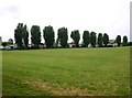
Redlands mobile home park, Chesterton Hill
View WSW towards the northern edge of the park, from the entrance driveway.
Image: © David P Howard
Taken: 26 May 2010
0.03 miles
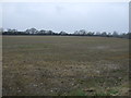
3
Footpath to Lighthorne from Chesterton Hill
Looking SW along the path as it zigzags.
Image: © David P Howard
Taken: 26 May 2010
0.22 miles
4
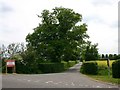
Entrance drive to Redlands Farm from B4100
Drive to Redlands Farm and Redlands mobile home park.
Image: © David P Howard
Taken: 26 May 2010
0.25 miles
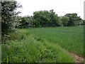
5
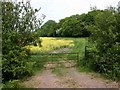
Bridleway round Chesterton Wood from B4100
Image: © David P Howard
Taken: 26 May 2010
0.25 miles