IMAGES TAKEN NEAR TO
Rosedale Road, WARWICK, CV34 8AH
Introduction
This page details the photographs taken nearby to Rosedale Road, CV34 8AH by members of the Geograph project.
The Geograph project started in 2005 with the aim of publishing, organising and preserving representative images for every square kilometre of Great Britain, Ireland and the Isle of Man.

There are currently over 7.5m images from over14,400 individuals and you can help contribute to the project by visiting https://www.geograph.org.uk
Image Map (Loading...)


Getting Data...Please wait
Leaflet Map data © OpenStreetMap
Images are licensed for reuse under creativecommons.org/licenses/by-sa/2.0
Notes
- Clicking on the map will re-center to the selected point.
- The higher the marker number, the further away the image location is from the centre of the postcode.
Image Listing (31 Images Found)
Images are licensed for reuse under creativecommons.org/licenses/by-sa/2.0
Image
Details
Distance
1
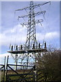
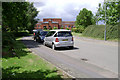
Europa Way, Warwick
High voltage power lines pass over Myton but go underground to cross Heathcote and Warwick Gates estates.
They were undergrounded only after a long struggle between the local authority, the power company and the developer.
They emerge in Whitnash and continue towards Harbury.
Image: © Robin Stott
Taken: 9 Mar 2009
0.07 miles

3
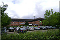
Holiday Inn, Olympus Avenue, Tachbrook Park, Warwick/Leamington
A less inviting hotel I never saw. Tachbrook Park has evolved into a mix of business, retail and leisure uses. It was a response to the approach of the M40 extension in the 1980s, filling in the urban fringe farmland between existing industrial estates south of Leamington. The laughable road names all refer to Greek mythology.
Image: © Robin Stott
Taken: 23 Jul 2009
0.10 miles
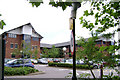
4
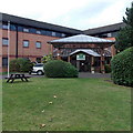
Entrance to a Holiday Inn near Leamington Spa
Accessed from Olympus Avenue, Tachbrook Park, the hotel is named Holiday Inn Leamington Spa - Warwick. The hotel is not located in either place, though the SW boundary of Royal Leamington Spa is a few hundred metres away.
Image: © Jaggery
Taken: 18 Oct 2014
0.10 miles
5
A452 Europa Way, Warwick
Portentous offices and 'tree' sculpture on the Tachbrook Park business park.
First occupied by the Heart of England Building Society who were taken over by the Cheltenham & Gloucester.
They now house a large firm of solicitors, Wright Hassall.
The area is technically in Warwick but feels more like south Leamington.
Image: © Robin Stott
Taken: 9 Mar 2009
0.10 miles

7
West end of Apollo Way, Tachbrook Park, Warwick/Leamington
Tachbrook Park has evolved into a mix of business, retail and leisure uses. It was a response to the approach of the M40 extension in the 1980s, filling in the urban fringe farmland between existing industrial estates south of Leamington. The laughable road names all refer to Greek mythology. Here the view is to Olympus Avenue and the rear of the offices of Wright Hassall, solicitors; it was originally developed for the Heart of England Building Society but they were taken over by the C&G, who were themselves acquired by Lloyds TSB, I think. This preposterous pile fronts Europa Way, Leamington's feeder to the M40: see Image
Image: © Robin Stott
Taken: 23 Jul 2009
0.13 miles
8
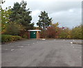
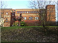
Holiday Inn electricity substation near Leamington Spa
The Central Networks electricity substation is in a corner of
a Holiday Inn http://www.geograph.org.uk/photo/4213267 car park near Olympus Avenue, Tachbrook Park.
Image: © Jaggery
Taken: 18 Oct 2014
0.13 miles
9

Wright Hassall office, Leamington Spa
Viewed across Olympus Avenue from the corner of Apollo Way. No doubt if this firm of solicitors were in the least bothered by jokes about their name, they would have called themselves Hassall Wright.
Image: © Jaggery
Taken: 18 Oct 2014
0.13 miles
10
Offices, Olympus Avenue, Tachbrook Park, Warwick/Leamington
The offices of Millward Brown, market research company, perhaps win gold in the ugliness Olympics that is Tachbrook Park. It was a response to the approach of the M40 extension in the 1980s, filling in the urban fringe farmland between existing industrial estates south of Leamington. The laughable road names all refer to Greek mythology.
Image: © Robin Stott
Taken: 23 Jul 2009
0.15 miles