IMAGES TAKEN NEAR TO
Heathcote Lane, WARWICK, CV34 6SR
Introduction
This page details the photographs taken nearby to Heathcote Lane, CV34 6SR by members of the Geograph project.
The Geograph project started in 2005 with the aim of publishing, organising and preserving representative images for every square kilometre of Great Britain, Ireland and the Isle of Man.

There are currently over 7.5m images from over14,400 individuals and you can help contribute to the project by visiting https://www.geograph.org.uk
Image Map
Images are licensed for reuse under creativecommons.org/licenses/by-sa/2.0
Notes
- Clicking on the map will re-center to the selected point.
- The higher the marker number, the further away the image location is from the centre of the postcode.
Image Listing (64 Images Found)
Images are licensed for reuse under creativecommons.org/licenses/by-sa/2.0
Image
Details
Distance
1
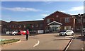
Royal Leamington Spa Rehabilitation Hospital, Heathcote Lane
The hospital has greatly increased in size over the years. It is part of the South Warwickshire NHS Foundation Trust (SWIFT). It is home to the Central England Rehabilitation Unit (CERU).
Image: © Robin Stott
Taken: 18 Sep 2019
0.01 miles
2
Eastern wing of the Royal Leamington Spa Rehabilitation Hospital, Heathcote Lane
The hospital has greatly increased in size over the years. It is part of the South Warwickshire NHS Foundation Trust (SWIFT). It is home to the Central England Rehabilitation Unit (CERU).
Image: © Robin Stott
Taken: 20 Sep 2019
0.03 miles
3
HSBC Exchange car park, Trident Park, south Leamington
The distinctive building was occupied by Merrill Lynch until recently, following its beginnings as a building society call centre. In the background is the Heathcote Rehabilitation Hospital on Heathcote Lane. The OS Landranger map for this and surrounding squares is seriously out of date.
Image: © Robin Stott
Taken: 30 Jul 2009
0.03 miles
4
HSBC Exchange building, Trident Park, south Leamington
Occupied by Merrill Lynch until recently, following its beginnings as a call centre. Seen from the vacant plot 4200. The south side of AP/Raical Clutches appears on the right. The OS Landranger map for SP3163 is seriously out of date.
Image: © Robin Stott
Taken: 30 Jul 2009
0.03 miles
5
Rehabilitation Hospital
Formerly an Isolation Hospital, this complex is now isolated in a square buried under modern housing estates and business parks
Image: © David Stowell
Taken: 21 May 2005
0.03 miles
6
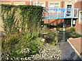
View of courtyard garden
This is a view of the courtyard garden at the hospital, designed for patient use. It includes a sensory area and fish pond.
Image: © Verity Stokes
Taken: 19 Oct 2007
0.03 miles
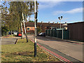
7
Circulation and parking, Leamington Rehab Hospital
Also known as Heathcote Hospital; for a little history see https://www.geograph.org.uk/photo/6414082
Access to the fenced compound, left, is clearly restricted, arousing curiosity, but there are no clues.
Image: © Robin Stott
Taken: 17 Jun 2022
0.03 miles
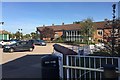
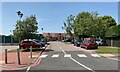
8
Circulation, Royal Leamington Spa Rehabilitation Hospital, Heathcote Lane
The hospital has greatly increased in size over the years. It is part of the South Warwickshire NHS Foundation Trust (SWIFT). It is home to the Central England Rehabilitation Unit (CERU). In the background is the eastern wing.
Image: © Robin Stott
Taken: 18 Sep 2019
0.04 miles
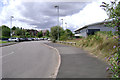
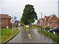
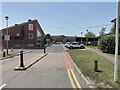
9

Heathcote Lane, south Leamington
Looking towards Heathcote Rehabilitation Hospital Image
Image: © Robin Stott
Taken: 30 Jul 2009
0.04 miles
10
Rehabilitation Hospital, Heathcote, Leamington
One of the two vehicular entrances to the site. The hospital has expanded over the years, taking patients from beyond Warwickshire. There are units for treating brain injuries and strokes. https://www.swft.nhs.uk/our-hospitals/leamington-spa-hospital
Image: © Robin Stott
Taken: 17 Jun 2022
0.04 miles