IMAGES TAKEN NEAR TO
Banbury Road, WARWICK, CV34 6LQ
Introduction
This page details the photographs taken nearby to Banbury Road, CV34 6LQ by members of the Geograph project.
The Geograph project started in 2005 with the aim of publishing, organising and preserving representative images for every square kilometre of Great Britain, Ireland and the Isle of Man.

There are currently over 7.5m images from over14,400 individuals and you can help contribute to the project by visiting https://www.geograph.org.uk
Image Map (Loading...)


Getting Data...Please wait
Leaflet Map data © OpenStreetMap
Images are licensed for reuse under creativecommons.org/licenses/by-sa/2.0
Notes
- Clicking on the map will re-center to the selected point.
- The higher the marker number, the further away the image location is from the centre of the postcode.
Image Listing (122 Images Found)
Images are licensed for reuse under creativecommons.org/licenses/by-sa/2.0
Image
Details
Distance
1
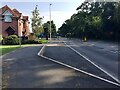
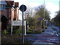
Changes on Banbury Road, Warwick
The recent relocation of King's High School for Girls to the Warwick School site has required light signals at the entrance and a layby. There are now light signals at the Gallows Hill turn down the road. In 2009 it was a clear run, as seen in this similar view Image
Image: © Robin Stott
Taken: 20 Sep 2020
0.03 miles
2
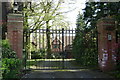
Gated housing, Bridgend, Warwick
Two properties and ancillary buildings are shoe-horned into the original plot - about 0.6 hectares of oak woodland.
The adjoining property has a plot of over 0.6 hectares all to itself.
Image: © Robin Stott
Taken: 13 Apr 2009
0.06 miles
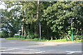
3
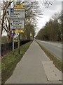
All the signs, Banbury Road, Warwick, 2018
The road sign is supplemented by directions to some of the many new estates going up in south Warwick.
Image: © Robin Stott
Taken: 1 Apr 2018
0.06 miles
5
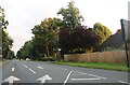
Banbury Road A425, looking SE
All the signs…
Image: © Robin Stott
Taken: 9 Mar 2009
0.08 miles
6
The new home, King's High School for Girls, Warwick School site, Banbury Road
Last photographed in February 2018 Image Parts of the former town centre site are now flattened and presumed to be awaiting development.
Image: © Robin Stott
Taken: 20 Sep 2020
0.08 miles
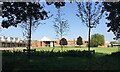
7
Myton Fields, Warwick
Part of the greenspace has been given over to a weekend rowing event on the River Avon.
Image: © Robin Stott
Taken: 22 Aug 2009
0.08 miles
9
![Warwick houses [176]](https://s1.geograph.org.uk/geophotos/06/63/16/6631689_f809ecbf_120x120.jpg)
Warwick houses [176]
Number 107 Bridge End is 17th century timber framed, much of the building covered in modern half timbering. Listed, grade II, with details at: https://historicengland.org.uk/listing/the-list/list-entry/1035517
A market town and county town of Warwickshire, Warwick lies on the River Avon, 11 miles (18 kilometres) south of Coventry. There is evidence of unbroken habitation from the 6th century AD with signs of Neolithic and Roman activity before that date. It was a Saxon burh in the 9th century and Warwick Castle was built during the Norman Conquest. Much of the town was destroyed in The Great Fire of Warwick in 1694. Warwick Racecourse is located just west of the town centre. The Grand Union Canal passes through the town and the restored Saltisford Canal Arm is close to the town centre.
Image: © Michael Dibb
Taken: 5 Aug 2020
0.12 miles
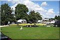
10
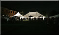
The end of an evening, Warwick Folk Festival 2016
The Warwick Folk Festival takes place in the grounds of Warwick School over a weekend in summer. Some events take place in the town. https://www.efestivals.co.uk/festivals/warwick/2017/ http://www.warwickschool.org
Image: © Robin Stott
Taken: 22 Jul 2016
0.12 miles