IMAGES TAKEN NEAR TO
Byron Avenue, WARWICK, CV34 6LB
Introduction
This page details the photographs taken nearby to Byron Avenue, CV34 6LB by members of the Geograph project.
The Geograph project started in 2005 with the aim of publishing, organising and preserving representative images for every square kilometre of Great Britain, Ireland and the Isle of Man.

There are currently over 7.5m images from over14,400 individuals and you can help contribute to the project by visiting https://www.geograph.org.uk
Image Map
Images are licensed for reuse under creativecommons.org/licenses/by-sa/2.0
Notes
- Clicking on the map will re-center to the selected point.
- The higher the marker number, the further away the image location is from the centre of the postcode.
Image Listing (83 Images Found)
Images are licensed for reuse under creativecommons.org/licenses/by-sa/2.0
Image
Details
Distance
2
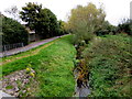
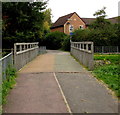
Gog Brook, Warwick
Viewed from this http://www.geograph.org.uk/photo/4689452 footbridge. The sluggish brook waters probably mostly evaporate or percolate into the ground. Some of the water ends up in the River Avon.
Image: © Jaggery
Taken: 3 Oct 2015
0.04 miles
3
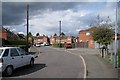
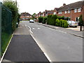
Byron Avenue, Forbes Estate, Warwick
All the roads on the estate are named after English poets.
Image: © Robin Stott
Taken: 28 Aug 2009
0.04 miles
4
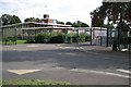
Newburgh Primary School, Kipling Avenue, Warwick
Image: © Robin Stott
Taken: 28 Aug 2009
0.05 miles
5
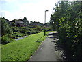
West along Kipling Avenue, Warwick
Towards Byron Avenue. The Newburgh Primary School perimeter fence is on the left.
Image: © Jaggery
Taken: 3 Oct 2015
0.05 miles
6
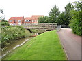
Bridge over Gog Brook
This is a view south-west along Gog Brook towards the bridge between Chase meadow and the adjacent residential estate. The brook often has ducks and finches along its banks.
Image: © Jeremy Worrell
Taken: 17 Jun 2007
0.06 miles
7
Gog Brook footbridge, Warwick
The bridge carries a footpath and cycleway over the brook. http://www.geograph.org.uk/photo/468954 to a side view.
Image: © Jaggery
Taken: 3 Oct 2015
0.06 miles
9
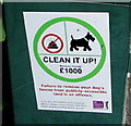
CLEAN IT UP! notice, Kipling Avenue, Warwick
Located here, http://www.geograph.org.uk/photo/4688908 the Warwick District Council notice shows a maximum £1,000 penalty for failure to remove your dog's faeces from publicly-accessible land.
Image: © Jaggery
Taken: 3 Oct 2015
0.06 miles
10
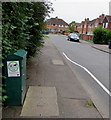
Kipling Avenue telecoms box, Warwick
http://www.geograph.org.uk/photo/4688903 to a closer view of the notice on the box.
Image: © Jaggery
Taken: 3 Oct 2015
0.06 miles