IMAGES TAKEN NEAR TO
Cressida Close, WARWICK, CV34 6DZ
Introduction
This page details the photographs taken nearby to Cressida Close, CV34 6DZ by members of the Geograph project.
The Geograph project started in 2005 with the aim of publishing, organising and preserving representative images for every square kilometre of Great Britain, Ireland and the Isle of Man.

There are currently over 7.5m images from over14,400 individuals and you can help contribute to the project by visiting https://www.geograph.org.uk
Image Map
Images are licensed for reuse under creativecommons.org/licenses/by-sa/2.0
Notes
- Clicking on the map will re-center to the selected point.
- The higher the marker number, the further away the image location is from the centre of the postcode.
Image Listing (66 Images Found)
Images are licensed for reuse under creativecommons.org/licenses/by-sa/2.0
Image
Details
Distance
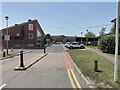
1
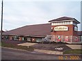
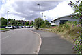
Co-op Store at Warwickgates
District Centre including convenience store, takeaways and chemist.
Image: © David Walton
Taken: 10 Feb 2002
0.01 miles
2
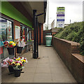
My Coffee Station, Co-operative Food, Cressida Close, Heathcote, Leamington
Image: © Robin Stott
Taken: 7 Jun 2018
0.02 miles
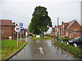
3
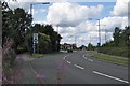
Lighting columns, Heathcote Lane
Approaching the junction with Poseidon Way and Othello Avenue, at a cloudy moment.
Image: © Robin Stott
Taken: 22 Aug 2009
0.02 miles
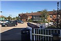
4
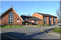
Warwick Gates Community Church and church hall, Cressida Close, Leamington
This is part of a local centre for the Warwick Gates estate and passing trade on Heathcote Lane. There's a doctor's surgery to the left and local shops, including a Co-op convenience store, to the right.
Image: © Robin Stott
Taken: 29 Dec 2015
0.02 miles
5
HSBC Exchange car park, Trident Park, south Leamington
The distinctive building was occupied by Merrill Lynch until recently, following its beginnings as a building society call centre. In the background is the Heathcote Rehabilitation Hospital on Heathcote Lane. The OS Landranger map for this and surrounding squares is seriously out of date.
Image: © Robin Stott
Taken: 30 Jul 2009
0.05 miles
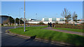
6
HSBC Exchange building, Trident Park, south Leamington
Occupied by Merrill Lynch until recently, following its beginnings as a call centre. Seen from the vacant plot 4200. The south side of AP/Raical Clutches appears on the right. The OS Landranger map for SP3163 is seriously out of date.
Image: © Robin Stott
Taken: 30 Jul 2009
0.05 miles
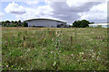
7
Rehabilitation Hospital
Formerly an Isolation Hospital, this complex is now isolated in a square buried under modern housing estates and business parks
Image: © David Stowell
Taken: 21 May 2005
0.05 miles
8
Eastern wing of the Royal Leamington Spa Rehabilitation Hospital, Heathcote Lane
The hospital has greatly increased in size over the years. It is part of the South Warwickshire NHS Foundation Trust (SWIFT). It is home to the Central England Rehabilitation Unit (CERU).
Image: © Robin Stott
Taken: 20 Sep 2019
0.05 miles
9
Rehabilitation Hospital, Heathcote, Leamington
One of the two vehicular entrances to the site. The hospital has expanded over the years, taking patients from beyond Warwickshire. There are units for treating brain injuries and strokes. https://www.swft.nhs.uk/our-hospitals/leamington-spa-hospital
Image: © Robin Stott
Taken: 17 Jun 2022
0.05 miles
10
Junction of Poseidon Way and Heathcote Lane, south Leamington
Business and industry in south Leamington are still undergoing a slow transformation. On the left, Exchange Place, possibly home to the Focus Learning Trust; some websites say it is available to rent. The long white fascia is on the ageing single-storey premises of Caparo. Beyond it the colossal Wolseley warehouse for building materials and components, dating from just before the financial crisis of 2008: unfortunate timing Image The fence on the right is to the garden of the more recent Royal Horse public house.
Image: © Robin Stott
Taken: 29 Dec 2015
0.05 miles