
IMAGES TAKEN NEAR TO
West Street, WARWICK, CV34 6AJ
Introduction
This page details the photographs taken nearby to West Street, CV34 6AJ by members of the Geograph project.
The Geograph project started in 2005 with the aim of publishing, organising and preserving representative images for every square kilometre of Great Britain, Ireland and the Isle of Man.

There are currently over 7.5m images from over14,400 individuals and you can help contribute to the project by visiting https://www.geograph.org.uk
Image Map
Images are licensed for reuse under creativecommons.org/licenses/by-sa/2.0
Notes
- Clicking on the map will re-center to the selected point.
- The higher the marker number, the further away the image location is from the centre of the postcode.
Image Listing (327 Images Found)
Images are licensed for reuse under creativecommons.org/licenses/by-sa/2.0
Image
Details
Distance
1
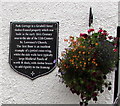
Park Cottage plaque, Warwick
On this http://www.geograph.org.uk/photo/4690770 Grade II listed early 16th century building.
Image: © Jaggery
Taken: 3 Oct 2015
0.03 miles
2
![Warwick houses [141]](https://s1.geograph.org.uk/geophotos/06/62/62/6626261_33d15ba1_120x120.jpg)
Warwick houses [141]
Numbers 113 and 115 West Street, was, until recently, divided into two dwellings. Originally built in the early 16th century, timber framed and jettied, the building has been altered and extended. Listed, grade II, with details at: https://historicengland.org.uk/listing/the-list/list-entry/1299683
A market town and county town of Warwickshire, Warwick lies on the River Avon, 11 miles (18 kilometres) south of Coventry. There is evidence of unbroken habitation from the 6th century AD with signs of Neolithic and Roman activity before that date. It was a Saxon burh in the 9th century and Warwick Castle was built during the Norman Conquest. Much of the town was destroyed in The Great Fire of Warwick in 1694. Warwick Racecourse is located just west of the town centre. The Grand Union Canal passes through the town and the restored Saltisford Canal Arm is close to the town centre.
Image: © Michael Dibb
Taken: 5 Aug 2020
0.03 miles
3
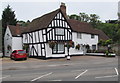
Park Cottage, Warwick
Viewed across West Street. A plaque http://www.geograph.org.uk/photo/4690773 on the wall states that Park Cottage is a Grade II listed timber-framed property which was built in the early 16th century near the site of the 12th century St Lawrence's Church.
The first floor is an excellent example of a jettied cross-wing whilst the side walls have typically large medieval panels of wattle & daub, with timber braces to add rigidity to the framing.
Image: © Jaggery
Taken: 3 Oct 2015
0.03 miles
4
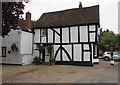
Park Cottage side wall, Warwick
The plaque http://www.geograph.org.uk/photo/4690773 on the front of the Grade II listed early 16th century building states that this side wall has typically large medieval panels of wattle & daub, with timber braces to add rigidity to the framing.
Image: © Jaggery
Taken: 3 Oct 2015
0.03 miles
5
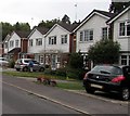
Stuart Close houses, Warwick
Part of a cul-de-sac on the east side of West Street.
Image: © Jaggery
Taken: 3 Oct 2015
0.03 miles
6
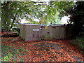
Tudor Court electricity substation, Warwick
Western Power Distribution electricity substation inside a wooden enclosure near the corner of West Street.
Image: © Jaggery
Taken: 3 Oct 2015
0.03 miles
7
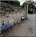
From West Street to Stratford Road, Warwick
Name signs alongside the A429. The left turn is the Stratford Road entrance http://www.geograph.org.uk/photo/4684619 to Warwick Castle grounds.
Image: © Jaggery
Taken: 3 Oct 2015
0.03 miles
8
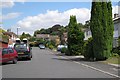
Stuart Close, Warwick
One of a number of residential developments sandwiched between West Street/Stratford Road and the boundary of Castle Park.
Image: © Robin Stott
Taken: 27 Aug 2009
0.04 miles
9
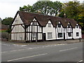
Grade II listed 109 and 111 West Street, Warwick
Five gables but only two front doors on the building dating from the 17th century, later restored and altered. Grade II listed in 1973.
Image: © Jaggery
Taken: 3 Oct 2015
0.04 miles
10
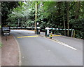
Automatic barriers across an entrance road to Warwick Castle
This road is accessed from the A429 Stratford Road behind the camera.
Ahead is an extensive area of car parks and areas for tourist coach parking.
Image: © Jaggery
Taken: 3 Oct 2015
0.04 miles