IMAGES TAKEN NEAR TO
West Street, WARWICK, CV34 6AB
Introduction
This page details the photographs taken nearby to West Street, CV34 6AB by members of the Geograph project.
The Geograph project started in 2005 with the aim of publishing, organising and preserving representative images for every square kilometre of Great Britain, Ireland and the Isle of Man.

There are currently over 7.5m images from over14,400 individuals and you can help contribute to the project by visiting https://www.geograph.org.uk
Image Map
Images are licensed for reuse under creativecommons.org/licenses/by-sa/2.0
Notes
- Clicking on the map will re-center to the selected point.
- The higher the marker number, the further away the image location is from the centre of the postcode.
Image Listing (891 Images Found)
Images are licensed for reuse under creativecommons.org/licenses/by-sa/2.0
Image
Details
Distance
1
![Warwick houses [122]](https://s1.geograph.org.uk/geophotos/06/62/43/6624337_13eaa26a_120x120.jpg)
Warwick houses [122]
Number 31 West Street is probably originally a timber framed 2-bay open hall of the late 15th or early 16th century. The hall was floored, possibly in the 17th century and in the early 19th century the house was remodelled and faced in brick.
Listed, grade II, with details at: https://historicengland.org.uk/listing/the-list/list-entry/1376010
A market town and county town of Warwickshire, Warwick lies on the River Avon, 11 miles (18 kilometres) south of Coventry. There is evidence of unbroken habitation from the 6th century AD with signs of Neolithic and Roman activity before that date. It was a Saxon burh in the 9th century and Warwick Castle was built during the Norman Conquest. Much of the town was destroyed in The Great Fire of Warwick in 1694. Warwick Racecourse is located just west of the town centre. The Grand Union Canal passes through the town and the restored Saltisford Canal Arm is close to the town centre.
Image: © Michael Dibb
Taken: 5 Aug 2020
0.01 miles
2
![Warwick houses [123]](https://s3.geograph.org.uk/geophotos/06/62/43/6624343_daebf1e6_120x120.jpg)
Warwick houses [123]
Number 33 West Street is early 19th century in red brick. Listed, grade II, with details at: https://historicengland.org.uk/listing/the-list/list-entry/1376011
A market town and county town of Warwickshire, Warwick lies on the River Avon, 11 miles (18 kilometres) south of Coventry. There is evidence of unbroken habitation from the 6th century AD with signs of Neolithic and Roman activity before that date. It was a Saxon burh in the 9th century and Warwick Castle was built during the Norman Conquest. Much of the town was destroyed in The Great Fire of Warwick in 1694. Warwick Racecourse is located just west of the town centre. The Grand Union Canal passes through the town and the restored Saltisford Canal Arm is close to the town centre.
Image: © Michael Dibb
Taken: 5 Aug 2020
0.01 miles
3
![Warwick houses [124]](https://s3.geograph.org.uk/geophotos/06/62/49/6624999_ca03148b_120x120.jpg)
Warwick houses [124]
Number 37 West Street is 18th century, somewhat altered, in stuccoed brick. Listed, grade II, with details at: https://historicengland.org.uk/listing/the-list/list-entry/1035354
A market town and county town of Warwickshire, Warwick lies on the River Avon, 11 miles (18 kilometres) south of Coventry. There is evidence of unbroken habitation from the 6th century AD with signs of Neolithic and Roman activity before that date. It was a Saxon burh in the 9th century and Warwick Castle was built during the Norman Conquest. Much of the town was destroyed in The Great Fire of Warwick in 1694. Warwick Racecourse is located just west of the town centre. The Grand Union Canal passes through the town and the restored Saltisford Canal Arm is close to the town centre.
Image: © Michael Dibb
Taken: 5 Aug 2020
0.01 miles
5
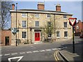
Black Friar's House, Warwick
A building with character.
Image: © Kenneth Allen
Taken: 14 Apr 2007
0.01 miles
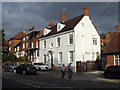
6
Alms Houses, Warwick
The inscription on the plaque reads, "For the love of God and in memory of their mother Louisa Harris. These Alms houses were rebuilt by their daughter Louisa H& Julia Harris A.D.1889"
Image: © Kenneth Allen
Taken: 14 Apr 2007
0.01 miles
7
![Warwick houses [120]](https://s3.geograph.org.uk/geophotos/06/62/42/6624231_a3ab67af_120x120.jpg)
Warwick houses [120]
Number 25 West Street is late 17th or early 18th century in red brick with stone quoins. The ground floor bay window and the porch are modern. Listed, grade II, with details at: https://historicengland.org.uk/listing/the-list/list-entry/1364846
A market town and county town of Warwickshire, Warwick lies on the River Avon, 11 miles (18 kilometres) south of Coventry. There is evidence of unbroken habitation from the 6th century AD with signs of Neolithic and Roman activity before that date. It was a Saxon burh in the 9th century and Warwick Castle was built during the Norman Conquest. Much of the town was destroyed in The Great Fire of Warwick in 1694. Warwick Racecourse is located just west of the town centre. The Grand Union Canal passes through the town and the restored Saltisford Canal Arm is close to the town centre.
Image: © Michael Dibb
Taken: 5 Aug 2020
0.01 miles
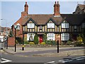
8
![Warwick houses [121]](https://s2.geograph.org.uk/geophotos/06/62/42/6624234_332dd06d_120x120.jpg)
Warwick houses [121]
Numbers 27 and 29 West Street are 18th century in red brick. Listed, grade II, with details at: https://historicengland.org.uk/listing/the-list/list-entry/1035353
A market town and county town of Warwickshire, Warwick lies on the River Avon, 11 miles (18 kilometres) south of Coventry. There is evidence of unbroken habitation from the 6th century AD with signs of Neolithic and Roman activity before that date. It was a Saxon burh in the 9th century and Warwick Castle was built during the Norman Conquest. Much of the town was destroyed in The Great Fire of Warwick in 1694. Warwick Racecourse is located just west of the town centre. The Grand Union Canal passes through the town and the restored Saltisford Canal Arm is close to the town centre.
Image: © Michael Dibb
Taken: 5 Aug 2020
0.01 miles
9
35 West Street, Warwick
Just up from the Catholic church hall, right.
Image: © Robin Stott
Taken: 20 Sep 2013
0.02 miles
10
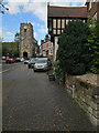
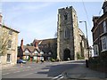
Warwick: West Street and Westgate
Looking up the hill towards the 15th-century tower of St James's Chapel (which is in Image) on an April afternoon.
Image: © John Sutton
Taken: 26 Apr 2014
0.02 miles