IMAGES TAKEN NEAR TO
Rylstone Way, WARWICK, CV34 5YF
Introduction
This page details the photographs taken nearby to Rylstone Way, CV34 5YF by members of the Geograph project.
The Geograph project started in 2005 with the aim of publishing, organising and preserving representative images for every square kilometre of Great Britain, Ireland and the Isle of Man.

There are currently over 7.5m images from over14,400 individuals and you can help contribute to the project by visiting https://www.geograph.org.uk
Image Map
Images are licensed for reuse under creativecommons.org/licenses/by-sa/2.0
Notes
- Clicking on the map will re-center to the selected point.
- The higher the marker number, the further away the image location is from the centre of the postcode.
Image Listing (94 Images Found)
Images are licensed for reuse under creativecommons.org/licenses/by-sa/2.0
Image
Details
Distance
1
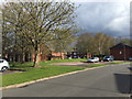
Kilnsey Grove, Woodloes Park, Warwick
Through the gap, right of centre, is a footpath through open space adjacent to the Grand Union Canal.
Image: © Robin Stott
Taken: 16 Apr 2016
0.03 miles
2
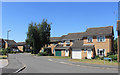
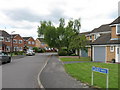
Greenway, Woodloes Park
Suburban housing on the north side of Warwick. An area of short residential streets and cul de sacs.
Image: © Des Blenkinsopp
Taken: 27 Jun 2018
0.06 miles
3
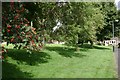
Buckden Close, Woodloes Park, Warwick
Among old people's bungalows, a formal square of open space, all banks and mounds to discourage any active recreation.
Image: © Robin Stott
Taken: 17 Aug 2009
0.06 miles
4
Suburbanized canal bank, rear of Pembroke Close, Warwick
Seen from the towpath near Kilnsey Grove on the Woodloes Park estate, across the Grand Union Canal from the viewpoint in Image
Image: © Robin Stott
Taken: 13 Aug 2009
0.07 miles
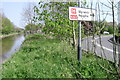
5
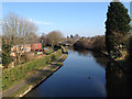
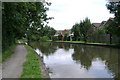
Grand Union Canal east from Scar Bank footbridge
On the left are houses in Kilnsey Grove. The light area on the right bank, just above centre, is the location of Image
Image: © Robin Stott
Taken: 1 Mar 2012
0.07 miles
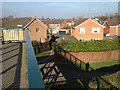
6
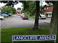
Langcliffe Avenue, Woodloes Park, Warwick
A typical close on the southern edge of the Woodloes Park estate. It adjoins the Canalside open space and footpath.
Image: © Robin Stott
Taken: 13 Aug 2009
0.08 miles
8
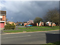
Single-storey houses, Addingham Close, Woodloes Park, Warwick
The view is across Woodloes Avenue South.
Image: © Robin Stott
Taken: 16 Apr 2016
0.08 miles
9
Millers Road, Warwick, meets the Grand Union Canal
Round the corner from Image Millers Road skirts the hospital car park in a tight bend.
Image: © Robin Stott
Taken: 20 Apr 2009
0.08 miles
10
Scar Bank footbridge and footpath from Greenway
Image: © Robin Stott
Taken: 1 Mar 2012
0.08 miles