IMAGES TAKEN NEAR TO
Stanton Walk, WARWICK, CV34 5UZ
Introduction
This page details the photographs taken nearby to Stanton Walk, CV34 5UZ by members of the Geograph project.
The Geograph project started in 2005 with the aim of publishing, organising and preserving representative images for every square kilometre of Great Britain, Ireland and the Isle of Man.

There are currently over 7.5m images from over14,400 individuals and you can help contribute to the project by visiting https://www.geograph.org.uk
Image Map
Images are licensed for reuse under creativecommons.org/licenses/by-sa/2.0
Notes
- Clicking on the map will re-center to the selected point.
- The higher the marker number, the further away the image location is from the centre of the postcode.
Image Listing (92 Images Found)
Images are licensed for reuse under creativecommons.org/licenses/by-sa/2.0
Image
Details
Distance
1
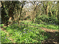
Bluebells in a patch of woodland by Twycross Walk, Woodloes Park, Warwick
The wood is a maze of informal paths – too many. There is a scout hut at the north end. Some flats can be made out through the trees.
Image: © Robin Stott
Taken: 17 Apr 2016
0.08 miles
2
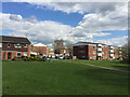
Houses and flats off Twycross Walk, Woodloes Park, north Warwick
Through the gap is Warner Close.
Image: © Robin Stott
Taken: 17 Apr 2016
0.09 miles
3
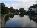
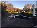
Grand Union Canal
Grand Union Canal at The Cape of Good Hope pub
Image: © Shaun Ferguson
Taken: 11 Oct 2016
0.10 miles
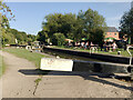
4
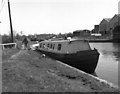
Cape Top Lock No 25, Grand Union Canal
The boatman seen leaving his boat here is probably making his way to the lockside pub, the 'Cape of Good Hope', to enjoy a pint before the 4 hours or so of hard work awaiting him as he tackles the 21 wide locks of the Hatton flight.
Image: © Dr Neil Clifton
Taken: 6 Apr 1972
0.11 miles
5
![Warwick canal [4]](https://s1.geograph.org.uk/geophotos/06/62/92/6629277_d1d8d09e_120x120.jpg)
Warwick canal [4]
Seen from the towpath is the bottom gate of Warwick Top Lock. The umbrellas belong to The Cape of Good Hope public house. The towpath is part of two long distance footpaths - The Grand Union Canal Walk and Shakespeare's Avon Way.
A market town and county town of Warwickshire, Warwick lies on the River Avon, 11 miles (18 kilometres) south of Coventry. There is evidence of unbroken habitation from the 6th century AD with signs of Neolithic and Roman activity before that date. It was a Saxon burh in the 9th century and Warwick Castle was built during the Norman Conquest. Much of the town was destroyed in The Great Fire of Warwick in 1694. Warwick Racecourse is located just west of the town centre. The Grand Union Canal passes through the town and the restored Saltisford Canal Arm is close to the town centre.
Image: © Michael Dibb
Taken: 4 Aug 2020
0.11 miles
6
Cape Top Lock, Grand Union Canal, north Warwick
On the public holiday after New Year we emerged here after walking down a very informal footpath by St John's Brook, starting here: Image The brook is culverted under the canal on its way to join the River Avon.
Image: © Robin Stott
Taken: 2 Jan 2017
0.11 miles
7
Drinks outside by Cape Top Lock, Grand Union Canal, Warwick
An outside area associated with the Cape of Good Hope pub Image; hopefully the picnic tables are safely spaced.
Image: © Robin Stott
Taken: 18 Sep 2020
0.11 miles
8
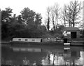
Canal Cruiser at Cape of Good Hope, Warwick
On the Grand Union Canal.
Image: © Dr Neil Clifton
Taken: 6 Jun 1977
0.12 miles
9
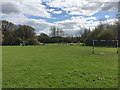
Public open space by Twycross Walk, Woodloes Park, north Warwick
Twycross Walk houses and flats are offstage left. Ahead and offstage right is the Wedgnock industrial estate. Warwick Scouts still have their hut in the little wood, left. Although blank white on the map, clumps of vegetation create pleasant spaces, frame inviting views.
Image: © Robin Stott
Taken: 17 Apr 2016
0.12 miles
10
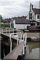
Cape Top Lock, Grand Union Canal
Unusually, the top gate of this lock has two handrails. This is to allow an easy crossing from the towpath to the Cape of Good Hope pub on the opposite bank. Narrowboat 'Dreamer' is moored outside.
Image: © Stephen McKay
Taken: 11 Aug 2021
0.12 miles