IMAGES TAKEN NEAR TO
Huddisdon Close, WARWICK, CV34 5TP
Introduction
This page details the photographs taken nearby to Huddisdon Close, CV34 5TP by members of the Geograph project.
The Geograph project started in 2005 with the aim of publishing, organising and preserving representative images for every square kilometre of Great Britain, Ireland and the Isle of Man.

There are currently over 7.5m images from over14,400 individuals and you can help contribute to the project by visiting https://www.geograph.org.uk
Image Map
Images are licensed for reuse under creativecommons.org/licenses/by-sa/2.0
Notes
- Clicking on the map will re-center to the selected point.
- The higher the marker number, the further away the image location is from the centre of the postcode.
Image Listing (124 Images Found)
Images are licensed for reuse under creativecommons.org/licenses/by-sa/2.0
Image
Details
Distance
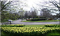
2
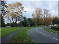
Roundabout on Coventry Road
The roundabout gives access to a lot of housing on the north side of Warwick.
Image: © Bill Boaden
Taken: 19 Apr 2019
0.04 miles
3
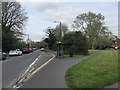
Bus stop and shelter, Coventry Road, Warwick
Just south of the junction with Primrose Hill and Spinney Hill. The open space, right, is bounded by Montague Road.
Image: © Robin Stott
Taken: 9 Apr 2019
0.05 miles
4
Coventry Road approaching Warwick
A busy junction: Primrose Hill comes in from Woodloes Park to the right; Spinney Hill is to the left.
Image: © Robin Stott
Taken: 21 Sep 2020
0.05 miles
5
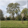
Grey Poplar near the Coventry Road roundabout, Warwick
Populus x canescens coming into leaf – impressive as only a big tree can be. Glimpses of cars and houses give an idea of the scale
Image: © Robin Stott
Taken: 9 Apr 2019
0.05 miles
6
Highway land bounded by Montague Road, Spinney Hill and Coventry Road, Warwick
The big tree catching the sun is Grey Poplar, Populus canescens. A different view of the area is Image from 2009.
Image: © Robin Stott
Taken: 18 Oct 2016
0.06 miles
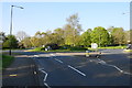
7
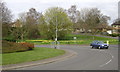
Coventry Road island, Warwick
A major node on the local road network. Blacklow Road climbs a hill in the distance.
Image: © Robin Stott
Taken: 31 Mar 2009
0.07 miles
8
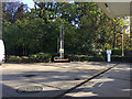
Pipes at BP filling station, Coventry Road, north Warwick
Guessing, they allow air to reach fuels in tanks below ground, thus maintaining atmospheric pressure, while allowing any fumes to be dispersed at a height.
Image: © Robin Stott
Taken: 24 Oct 2018
0.07 miles
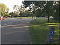
9
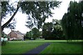
Greenspace and west end of Montague Road, Warwick
A strange greenspace of irregular shape at the junction of Coventry Road, Spinney Hill and Montague Road. Paths criss-cross it between mature trees and specimen shrubs.
Image: © Robin Stott
Taken: 17 Aug 2009
0.07 miles
10
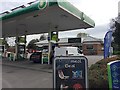
BP petrol filling station and shop, Coventry Road, Warwick
Always busy by a key junction, and as a local shop for the surrounding estates.
Image: © Robin Stott
Taken: 9 Apr 2019
0.07 miles