IMAGES TAKEN NEAR TO
The Precinct, WARWICK, CV34 5SR
Introduction
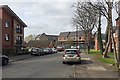
This page details the photographs taken nearby to The Precinct, CV34 5SR by members of the Geograph project.
The Geograph project started in 2005 with the aim of publishing, organising and preserving representative images for every square kilometre of Great Britain, Ireland and the Isle of Man.

There are currently over 7.5m images from over14,400 individuals and you can help contribute to the project by visiting https://www.geograph.org.uk
Image Map
Images are licensed for reuse under creativecommons.org/licenses/by-sa/2.0
Notes
- Clicking on the map will re-center to the selected point.
- The higher the marker number, the further away the image location is from the centre of the postcode.
Image Listing (109 Images Found)
Images are licensed for reuse under creativecommons.org/licenses/by-sa/2.0
Image
Details
Distance
1
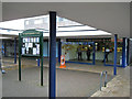
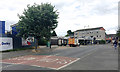
Blue Christmas lights, Spinney Hill Fish Bar
The sign carries notices for The Gap Community Centre which is believed to occupy the St John's Church Hall in Oakwood Grove. The fish bar is one of a row of shops on the west side of this neighbourhood shopping centre. Behind the camera on the east side is a single small supermarket which accommodates a handy sub-post office.
Image: © Robin Stott
Taken: 27 Dec 2012
0.00 miles
2
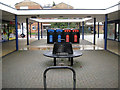
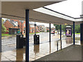
Street furniture, Spinney Hill shops
A symmetrical, visually 'safe' arrangement avoids covered walkways by and between the two rows of shops. Spinney Hill the road can be seen in the background.
Image: © Robin Stott
Taken: 27 Dec 2012
0.01 miles
3
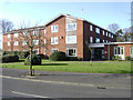
Woodside residential care home, Spinney Hill, Warwick
Operated by Warwickshire Care Services http://www.wcs-care.co.uk/our-homes/homes-for-older-people/woodside.aspx
Image: © Robin Stott
Taken: 11 Mar 2014
0.01 miles
4
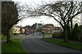
The end of Millbank, Warwick
Looking towards The Chantry, the last house in Greville Road, and Spinney Hill shops, right of centre.
Image: © Robin Stott
Taken: 20 Mar 2009
0.01 miles
5
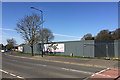
Bus stop on Spinney Hill for the shops and The Chantry, Warwick
The southern half of the estate is shown in outline on a map of 1938 and shown built 1953-68. The northern half, which includes this location, is shown built 1968-1983, so perhaps into the 1970s. Below the flats is a McColls convenience store which incorporates an excellent sub-post office counter. The single-storey buildings to the left include a fish and chip shop and an osteopath. Spinney Hill and Greville Road form part of a distributor road through the north Warwick estates.
Image: © Robin Stott
Taken: 10 Jul 2019
0.01 miles
6
Spinney Hill, Warwick, in the rain
Covered walkways serve two rows of shops which include a sub-post office within a small supermarket. There are bus stops and parking spaces. Up on the hill here there is a lot of local authority housing still, though how much has been sold, if any, is not known. There's quite a mix: conventional terraced houses, low- and medium-rise blocks of flats, old people's bungalows and a residential home, plus private residential developments.
Image: © Robin Stott
Taken: 29 Jun 2016
0.03 miles
7
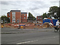
Early stages of construction on the Hobson?s Choice site, All Saints Road, Warwick
The derelict pub has gone. Flats are starting to go up on the site. Earlier views are Image, Image and Image
Image: © Robin Stott
Taken: 26 Jul 2013
0.03 miles
8
Site of Woodside residential care home, Spinney Hill, Warwick
Seen here in 2014: Image A new facility is being built for the same provider, Warwickshire Care Services Ltd https://www.wcs-care.co.uk
Image: © Robin Stott
Taken: 26 Mar 2018
0.03 miles
9
New residential care home being built on the site of Woodside, Spinney Hill, Warwick
The view is from the top of All Saints Road. The previous home was seen in Image
Image: © Robin Stott
Taken: 9 Apr 2019
0.03 miles
10

Early stages of construction on the Hobson?s Choice site, All Saints Road, Warwick
The derelict pub has gone. Flats are starting to go up on the site. Some floor slabs and drainage are in. Earlier views are Image, Image and Image
Image: © Robin Stott
Taken: 26 Jul 2013
0.04 miles