IMAGES TAKEN NEAR TO
Eliot Close, WARWICK, CV34 5RE
Introduction
This page details the photographs taken nearby to Eliot Close, CV34 5RE by members of the Geograph project.
The Geograph project started in 2005 with the aim of publishing, organising and preserving representative images for every square kilometre of Great Britain, Ireland and the Isle of Man.

There are currently over 7.5m images from over14,400 individuals and you can help contribute to the project by visiting https://www.geograph.org.uk
Image Map
Images are licensed for reuse under creativecommons.org/licenses/by-sa/2.0
Notes
- Clicking on the map will re-center to the selected point.
- The higher the marker number, the further away the image location is from the centre of the postcode.
Image Listing (41 Images Found)
Images are licensed for reuse under creativecommons.org/licenses/by-sa/2.0
Image
Details
Distance
4
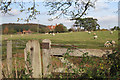
A field of sheep by Woodloes Lane
Looking towards Loes Farm.
Image: © Robin Stott
Taken: 15 Nov 2009
0.06 miles
5
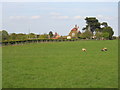
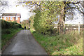
Old Farm
Looking across the square from Woodloes Lane to the farm buildings on edge of the square.
Image: © David Stowell
Taken: 29 Apr 2005
0.06 miles
9
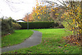
Greenspace at the rear of Eliot Close, Woodloes Park, Warwick
Image: © Robin Stott
Taken: 15 Nov 2009
0.08 miles