IMAGES TAKEN NEAR TO
Emscote Road, WARWICK, CV34 5QT
Introduction
This page details the photographs taken nearby to Emscote Road, CV34 5QT by members of the Geograph project.
The Geograph project started in 2005 with the aim of publishing, organising and preserving representative images for every square kilometre of Great Britain, Ireland and the Isle of Man.

There are currently over 7.5m images from over14,400 individuals and you can help contribute to the project by visiting https://www.geograph.org.uk
Image Map (Loading...)


Getting Data...Please wait
Leaflet Map data © OpenStreetMap
Images are licensed for reuse under creativecommons.org/licenses/by-sa/2.0
Notes
- Clicking on the map will re-center to the selected point.
- The higher the marker number, the further away the image location is from the centre of the postcode.
Image Listing (412 Images Found)
Images are licensed for reuse under creativecommons.org/licenses/by-sa/2.0
Image
Details
Distance
1
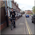
Texting? Tweeting? Checking Facebook? On a map? Cyclist, Portobello, Warwick
Cyclists, sometimes no-handed, on the phone are a not uncommon sight. This chap is heading for Leamington and is about to cross the River Avon by Portobello Bridge, behind the camera. On the right is busy Emscote Road.
Image: © Robin Stott
Taken: 23 Apr 2014
0.01 miles
2
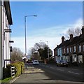
Emscote Road
The A445 approaching the bridge over the River Avon.
Image: © Gerald England
Taken: 4 Mar 2017
0.02 miles
3
Little brick boxes shoehorned in, Portobello, Warwick
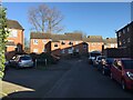
Above centre is the end house in Riverside View, a local housing association development in Grange Close. On the right is a group of tiny houses built on a plot at the east end of the terrace near Portobello Bridge Image On the left is a glimpse of the riverbank. This view is roughly the reverse of Image
Image: © Robin Stott
Taken: 23 Apr 2014
0.02 miles
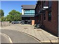
4
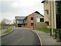
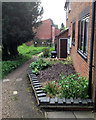
Avonside Health Centre, Portobello Way, Emscote, Warwick
The health centre, four years old at the time of the photo, and unoccupied Portobello House, right, were built on the site of the offices of Potterton's, the boiler manufacturer. Portobello Way, upgraded from a track, serves the rear of Greville Road, new social housing, allotments and other sites. A reverse view, in snow, is Image
Image: © Robin Stott
Taken: 19 Mar 2013
0.02 miles
5
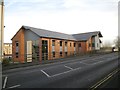
Avonside Health Centre, Portobello Way, Emscote, Warwick
Avonside has been in use for about five years. The GP practice was formerly in two houses in Emscote Road Image
Image: © Robin Stott
Taken: 10 Jan 2014
0.02 miles
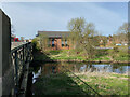
6
Gable of Avonside Health Centre across Portobello Bridge, southeast Warwick
The Health Centre opened in 2009. It is part of a development on the site of Potterton's offices and works, where they made boilers. Portobello Bridge over the River Avon marks the boundary between Warwick and Leamington. The view is from the riverside open space
Image: © Robin Stott
Taken: 15 Jul 2015
0.02 miles
7
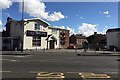
Indian restaurant, Bridge Street, Warwick
The River Cross been operating for several years and was last photographed in 2014 Image Judging by the building's alignment it was planned as the pub to serve the Bridge Street housing estate seen in the background. The estate first appears on a map of 1968-70, replacing streets of terraced houses (Sanders Street and Chapman Street) and some allotments. When we came to Warwick in the 1980s the pub was called The Greyhound, a reference to the dog-racing track up the river by Potterton's allotments. Sadly we have no photo of the stylish illuminated pub sign in the form of a greyhound: where did that go? The view is across Emscote Road during a fleeting gap in the traffic.
Image: © Robin Stott
Taken: 11 Sep 2019
0.02 miles
8
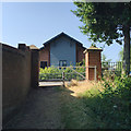
Being patient, Health Centre, Portobello Way, Warwick
Faced by coronavirus, Avonside Health Centre promptly changed its way of working to protect patients and staff. All communication with patients is via a website or by phone as explained in a notice Image Here, a patient with an appointment is identifying himself through the intercom before being let in, having assured reception staff that he is free of Covid-19 symptoms.
Image: © Robin Stott
Taken: 19 May 2020
0.03 miles
9
Avonside Health Centre and the River Avon, Warwick
The view from Royal Leamington Spa.
Image: © Robin Stott
Taken: 10 Apr 2022
0.03 miles