IMAGES TAKEN NEAR TO
Charles Court, WARWICK, CV34 5LZ
Introduction
This page details the photographs taken nearby to Charles Court, CV34 5LZ by members of the Geograph project.
The Geograph project started in 2005 with the aim of publishing, organising and preserving representative images for every square kilometre of Great Britain, Ireland and the Isle of Man.

There are currently over 7.5m images from over14,400 individuals and you can help contribute to the project by visiting https://www.geograph.org.uk
Image Map
Images are licensed for reuse under creativecommons.org/licenses/by-sa/2.0
Notes
- Clicking on the map will re-center to the selected point.
- The higher the marker number, the further away the image location is from the centre of the postcode.
Image Listing (82 Images Found)
Images are licensed for reuse under creativecommons.org/licenses/by-sa/2.0
Image
Details
Distance
1
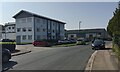
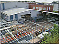
Budbrooke Industrial Estate, Warwick
The view is west along Budbrooke Road, a dead-end against the A46. It seemed busy enough but nearby there were empty premises and empty car parks. Charles Court, left, appears to be part-offices, part-residential. Image shows little outward change since 2009.
Image: © Robin Stott
Taken: 21 Sep 2020
0.02 miles
2
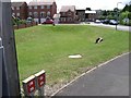
Stormwater lagoon, Wilmhurst Road, Warwick
This estate, which doesn't appear on the OS Explorer map, was built largely on the site of the derelict Yorkshire Cold Stores, alongside the railway.
Image: © Robin Stott
Taken: 13 Jul 2009
0.03 miles
3
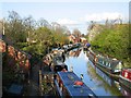
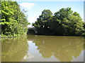
Saltisford Arm, Warwick
This length of canal once led to the terminus of the Warwick and Birmingham canal. With the coming of the Warwick and Napton canal, latterly the Grand Union Canal, it became a derelict appendage. In recent years much of this length has been restored, and is maintained by a canal trust. As can be seen it now provides a secluded mooring space for many narrowboats.
Image: © David Stowell
Taken: 18 Apr 2005
0.03 miles
4
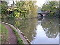
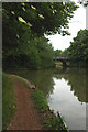
Grand Union canal at Warwick
The route of the Grand Union canal follows the canal to the left, beyond the bridge on the right is a branch to Saltisford Canal Centre.
Image: © Philip Halling
Taken: 31 Oct 2022
0.05 miles
5
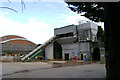
Scaffolding depot, Budbrooke industrial estate, Warwick
Seen from a footbridge over the railway, leading to Warwick Common.
Image: © Robin Stott
Taken: 13 Jul 2009
0.05 miles
6
Concrete batching plant, Budbrooke industrial estate, Warwick
Image: © Robin Stott
Taken: 13 Jul 2009
0.05 miles
7
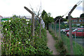
Footpath towards the railway, Budbrooke industrial estate
Image: © Robin Stott
Taken: 13 Jul 2009
0.05 miles
8
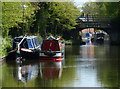
Grand Union Canal: Saltisford Arm entrance
Having moored up past the junction and walked back along the towpath this is a not particularly good view of the entrance to the arm. The white van is parked on the Budbrooke Road bridge. This is also the junction point of the former Warwick and Napton Canal with the Warwick and Birmingham Canal. The latter came from the right and went up the Saltisford Arm and terminated, while the former teed onto the latter and headed off to Napton on the left.
Image: © Nigel Cox
Taken: 5 Sep 2012
0.06 miles
9
Welcome to Warwick - turn left for the Grand Union Canal
Image: © Row17
Taken: 8 Jun 2009
0.06 miles
10
Grand Union Canal in Warwick
In the distance is the Budbrooke Road Bridge No 51a, crossing the Saltisford Arm of the Grand Union Canal.
Image: © Mat Fascione
Taken: 4 May 2015
0.06 miles