IMAGES TAKEN NEAR TO
Nelson Avenue, WARWICK, CV34 5LY
Introduction
This page details the photographs taken nearby to Nelson Avenue, CV34 5LY by members of the Geograph project.
The Geograph project started in 2005 with the aim of publishing, organising and preserving representative images for every square kilometre of Great Britain, Ireland and the Isle of Man.

There are currently over 7.5m images from over14,400 individuals and you can help contribute to the project by visiting https://www.geograph.org.uk
Image Map
Images are licensed for reuse under creativecommons.org/licenses/by-sa/2.0
Notes
- Clicking on the map will re-center to the selected point.
- The higher the marker number, the further away the image location is from the centre of the postcode.
Image Listing (224 Images Found)
Images are licensed for reuse under creativecommons.org/licenses/by-sa/2.0
Image
Details
Distance
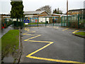
1
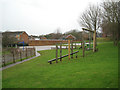
Play areas, All Saints Junior School, Nelson Avenue
Viewed through the security fence by the entrance at the end of Nelson Avenue. The fence to the left encloses staff parking spaces, with the school buildings further off to the left.
Image: © Robin Stott
Taken: 27 Dec 2012
0.02 miles
2
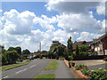
Nelson Avenue
A short residential road off George Road. The turning on the left is Dale Close. At the end of the street (in SP2966) is All Saints C of E Junior School.
Image: © Robin Stott
Taken: 27 Dec 2012
0.02 miles
3
Flats, All Saints Road
Occasionally trees and buildings complement each other.
Image: © Robin Stott
Taken: 20 Mar 2009
0.03 miles
4
All Saints Junior School entrance, Nelson Avenue
This is All Saints Church of England Junior School.
Image: © Robin Stott
Taken: 27 Dec 2012
0.03 miles
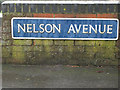
5
Nelson Avenue nameplate 2
A earlier-twentieth century nameplate using a condensed grotesque sans-serif typeface, not unlike Franklin Gothic Extra Condensed. Notice the closure of the space between the A and the V, an example of kerning that was perhaps a little overdone. Compare Image
Image: © Robin Stott
Taken: 27 Dec 2012
0.04 miles
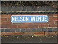
6
Nelson Avenue nameplate 1
A later-twentieth century nameplate using a version of the 'Goudy' typeface. Notice the closure of the space between the A and the V, an example of kerning that was perhaps a little overdone. Compare Image
Image: © Robin Stott
Taken: 27 Dec 2012
0.04 miles
7
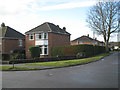
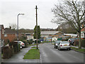
Detached corner house, George Road
Both George Road and Nelson Avenue, right, are lined with semi-detached houses, except on this corner.
Image: © Robin Stott
Taken: 27 Dec 2012
0.04 miles
8
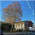
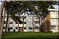
Birches at Rohan Gardens, Warwick
Many trees, like these birches, have hung on to their leaves well into December. Rohan Gardens is a development by Warwick District Council of part-owned flats for older people needing some care. The view is from All Saints Road.
Image: © Robin Stott
Taken: 10 Dec 2022
0.05 miles
9
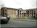
Rohan Gardens, apartments nearing completion, All Saints Road, Warwick
I think local authority flats or sheltered housing occupied this site before.
Image: © Robin Stott
Taken: 19 Mar 2013
0.05 miles