IMAGES TAKEN NEAR TO
Mulberry Drive, WARWICK, CV34 5JP
Introduction
This page details the photographs taken nearby to Mulberry Drive, CV34 5JP by members of the Geograph project.
The Geograph project started in 2005 with the aim of publishing, organising and preserving representative images for every square kilometre of Great Britain, Ireland and the Isle of Man.

There are currently over 7.5m images from over14,400 individuals and you can help contribute to the project by visiting https://www.geograph.org.uk
Image Map
Images are licensed for reuse under creativecommons.org/licenses/by-sa/2.0
Notes
- Clicking on the map will re-center to the selected point.
- The higher the marker number, the further away the image location is from the centre of the postcode.
Image Listing (203 Images Found)
Images are licensed for reuse under creativecommons.org/licenses/by-sa/2.0
Image
Details
Distance
1
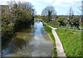
![Warwick canal [7]](https://s0.geograph.org.uk/geophotos/06/62/92/6629284_02a04696_120x120.jpg)
Warwick canal [7]
Seen from the bridge carrying Coventry Road, A429, over the Grand Union Canal is this view of the canal looking west.
A market town and county town of Warwickshire, Warwick lies on the River Avon, 11 miles (18 kilometres) south of Coventry. There is evidence of unbroken habitation from the 6th century AD with signs of Neolithic and Roman activity before that date. It was a Saxon burh in the 9th century and Warwick Castle was built during the Norman Conquest. Much of the town was destroyed in The Great Fire of Warwick in 1694. Warwick Racecourse is located just west of the town centre. The Grand Union Canal passes through the town and the restored Saltisford Canal Arm is close to the town centre.
Image: © Michael Dibb
Taken: 4 Aug 2020
0.02 miles
2
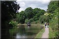
Grand Union Canal South of Woodloes Park
The canal passes through the suburbs of Warwick.
Image: © Glyn Baker
Taken: 17 Jul 2016
0.03 miles
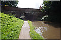
4
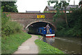
Grand Union Canal, Warwick
A narrowboat passes through bridge 49 which carries the A429 north of Warwick town centre.
Image: © Stephen McKay
Taken: 8 Aug 2010
0.04 miles
5
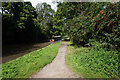
Ramp to the canal towpath from the Coventry Road bridge, Warwick
When it opened in 1800 as the Warwick and Napton Canal it passed through fields and parkland. The spiked parapet in the foreground, now breached, sent a brutal "Keep Out" message. Now as the Grand Union, the canal forms the southern boundary of the Woodloes Park estate, right. The ramp is one of several through Warwick and Leamington giving access to the towpath, which is well-used.
Image: © Robin Stott
Taken: 7 Feb 2018
0.04 miles
6
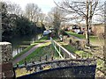
Grand Union Canal in Warwick
Looking west from the Coventry Road Bridge.
Image: © Mat Fascione
Taken: 18 Apr 2015
0.05 miles
7
![Warwick bridges [5]](https://s3.geograph.org.uk/geophotos/06/62/92/6629283_2f13ecd4_120x120.jpg)
Warwick bridges [5]
Bridge number 49 carries Coventry Road, A429, over the Grand Union Canal.
A market town and county town of Warwickshire, Warwick lies on the River Avon, 11 miles (18 kilometres) south of Coventry. There is evidence of unbroken habitation from the 6th century AD with signs of Neolithic and Roman activity before that date. It was a Saxon burh in the 9th century and Warwick Castle was built during the Norman Conquest. Much of the town was destroyed in The Great Fire of Warwick in 1694. Warwick Racecourse is located just west of the town centre. The Grand Union Canal passes through the town and the restored Saltisford Canal Arm is close to the town centre.
Image: © Michael Dibb
Taken: 4 Aug 2020
0.05 miles
8

Raising the parapet of Bridge 49, Grand Union Canal, Warwick
It's believed that the parapet was raised because boaters and boats were at risk from objects being dropped from the Coventry Road bridge.
Image: © Robin Stott
Taken: 30 Sep 2020
0.05 miles
10
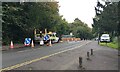
Single file on Coventry Road, Warwick
A short closure of the northbound lane protected contractors who were raising the parapet of bridge 49 over the Grand Union Canal: see Image
Image: © Robin Stott
Taken: 30 Sep 2020
0.05 miles