IMAGES TAKEN NEAR TO
Coventry Road, WARWICK, CV34 5HN
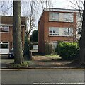
Introduction
This page details the photographs taken nearby to Coventry Road, CV34 5HN by members of the Geograph project.
The Geograph project started in 2005 with the aim of publishing, organising and preserving representative images for every square kilometre of Great Britain, Ireland and the Isle of Man.

There are currently over 7.5m images from over14,400 individuals and you can help contribute to the project by visiting https://www.geograph.org.uk
Image Map
Images are licensed for reuse under creativecommons.org/licenses/by-sa/2.0
Notes
- Clicking on the map will re-center to the selected point.
- The higher the marker number, the further away the image location is from the centre of the postcode.
Image Listing (455 Images Found)
Images are licensed for reuse under creativecommons.org/licenses/by-sa/2.0
Image
Details
Distance
1
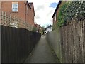
Footpath to Coventry Road from Lakin Road, Warwick
It must be a handy shortcut from residential Coventry Road to a corner shop and a pub in Lakin Road, and Warwick rail station. The slope of Coventry Road is discernible.
Image: © Robin Stott
Taken: 16 Apr 2016
0.02 miles
2
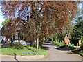
Coventry Road, Warwick - drive to Beech Cliffe and The Cliffe
This low-key drive, the only remaining drive to The Cliffe, leads to secluded developments hidden behind Coventry Road.
Image: © Robin Stott
Taken: 19 Apr 2009
0.03 miles
3
Nos 8 and 6, Lakin Road, Warwick
An expanse of DIY paving leads to a carport in need of repair. The neighbouring house, out of shot right, also has a carport – an unusual feature in more recent houses.
Image: © Robin Stott
Taken: 28 Aug 2013
0.03 miles
4
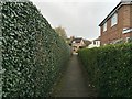
Footpath from Coventry Road to Lakin Road, Warwick
It must be a handy shortcut from residential Coventry Road to a corner shop and a pub in Lakin Road, and Warwick rail station.
Image: © Robin Stott
Taken: 16 Apr 2016
0.04 miles
5
Rear access to lock-up garages, Lakin Road, Warwick
Housing in Lakin Road shows a variety of styles from different periods.
Image: © Robin Stott
Taken: 3 Mar 2020
0.04 miles
6
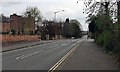
South on Cliff Hill, the southern end of Coventry Road in Warwick
The reverse view, from a train, is Image
Image: © Robin Stott
Taken: 9 Apr 2019
0.05 miles
7
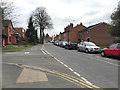
South on Lakin Road, Warwick
The southern half of the street is mixed housing; the northern half is dominated by Warwick Hospital. The view is from the corner of Remburn Gardens Image
Image: © Robin Stott
Taken: 21 Mar 2019
0.05 miles
8
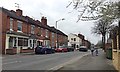
Northwest from the lower end of Lakin Road
Narrow Packmore Street is off to the left. Paradise Street is the turning by the Spar shop Image
Image: © Robin Stott
Taken: 21 Mar 2019
0.05 miles
9
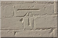
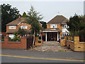
Cut Bench Mark, Wild Boar Public House
Bench Mark Database: http://www.bench-marks.org.uk/bm42840
Image: © Mark Anderson
Taken: 14 Apr 2012
0.05 miles
10
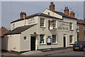
Wild Boar Public House, Lakin Road
There is a cut bench mark on the front of the pub and a closer view can be seen here: Image
Image: © Mark Anderson
Taken: 14 Apr 2012
0.05 miles