IMAGES TAKEN NEAR TO
Giles Court, Jones Road, CV34 5FB
Introduction
This page details the photographs taken nearby to Giles Court, Jones Road, CV34 5FB by members of the Geograph project.
The Geograph project started in 2005 with the aim of publishing, organising and preserving representative images for every square kilometre of Great Britain, Ireland and the Isle of Man.

There are currently over 7.5m images from over14,400 individuals and you can help contribute to the project by visiting https://www.geograph.org.uk
Image Map
Images are licensed for reuse under creativecommons.org/licenses/by-sa/2.0
Notes
- Clicking on the map will re-center to the selected point.
- The higher the marker number, the further away the image location is from the centre of the postcode.
Image Listing (182 Images Found)
Images are licensed for reuse under creativecommons.org/licenses/by-sa/2.0
Image
Details
Distance
1

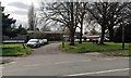
Former Ridgeway School, Montague Road, Warwick
Residential development, 'Montague Point', has been approved on this former County Council land. The view is from Bridge 49 over the Grand Union Canal at Coventry Road.
Image: © Robin Stott
Taken: 4 Jun 2021
0.02 miles
2
Parking in the grounds of the former Ridgeway School, Montague Road, Warwick
Seeing the Héras fencing I thought redevelopment had begun, but I was wrong. No change from Image, October 2016.
Image: © Robin Stott
Taken: 9 Apr 2019
0.02 miles
3
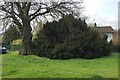
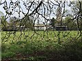
Yew tree, former Ridgeway School site, Montague Road, Warwick
What caught my attention about this tree was the drooping shoots. However, it was in flower: perhaps the weight of the flowers caused the young shoots to bend. Shoots and flowers: Image
Image: © Robin Stott
Taken: 9 Apr 2019
0.02 miles
4

Flowering shoots of yew, former Ridgeway School site, Montague Road, Warwick
Tree: Image
Image: © Robin Stott
Taken: 9 Apr 2019
0.02 miles
5
The former Ridgeway School, closed and boarded-up, Montague Road, Warwick
The school has moved to new buildings adjoining Woodloes Primary School on Deansway Image SchoolGuide.co.uk reports: "Ridgeway School moved to its new current premises in 2010 and caters for pupils with complex learning difficulties and autistic spectrum disorders." https://www.schoolguide.co.uk/schools/ridgeway-school-warwick One could imagine the County Council selling the site for residential development.
Image: © Robin Stott
Taken: 18 Oct 2016
0.02 miles
6
Demolition of former Ridgeway School, Montague Road, Warwick
Image: © Robin Stott
Taken: 21 Dec 2021
0.03 miles
7
Coming soon: Montague Point homes, Montague Road, Warwick
The former Ridgeway School will soon be gone. The site has been vacant for at least five years: Image
Image: © Robin Stott
Taken: 1 May 2021
0.03 miles
8
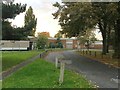
Former Ridgeway School seen from Coventry Road, Warwick
The buildings may or may not be secure. This ground is informally accessible: a man was walking his dog here.
Image: © Robin Stott
Taken: 9 Apr 2019
0.03 miles
9
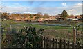
Ridgeway School site after demolition, Montague Road, Warwick
The view is from Coventry Road. A proposal for houses on the site, 'Montague Point', has been approved.
Image: © Robin Stott
Taken: 4 Dec 2021
0.03 miles
10
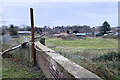
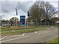
Pipes at BP filling station, Coventry Road, north Warwick
Guessing, they allow air to reach fuels in tanks below ground, thus maintaining atmospheric pressure, while allowing any fumes to be dispersed at a height.
Image: © Robin Stott
Taken: 24 Oct 2018
0.04 miles