IMAGES TAKEN NEAR TO
School Lane, WARWICK, CV34 5BG
Introduction
This page details the photographs taken nearby to School Lane, CV34 5BG by members of the Geograph project.
The Geograph project started in 2005 with the aim of publishing, organising and preserving representative images for every square kilometre of Great Britain, Ireland and the Isle of Man.

There are currently over 7.5m images from over14,400 individuals and you can help contribute to the project by visiting https://www.geograph.org.uk
Image Map
Images are licensed for reuse under creativecommons.org/licenses/by-sa/2.0
Notes
- Clicking on the map will re-center to the selected point.
- The higher the marker number, the further away the image location is from the centre of the postcode.
Image Listing (247 Images Found)
Images are licensed for reuse under creativecommons.org/licenses/by-sa/2.0
Image
Details
Distance
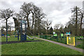
3
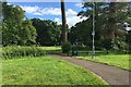
A scene in Priory Pools, Warwick
The Priory of St Sepulchre was a monastic foundation on top of the hill on which Warwick stands. It was demolished after the Dissolution and rebuilt from 1546 as The Priory, a large house in 40 acres (16 hectares) of parkland. In time the monks' fishponds became ornamental pools. Around 1850 the parkland was severed by the building of Brunel's Oxford to Birmingham railway. In the twentieth century the hilly parkland to the south eventually became Priory Park, much of it now a scheduled ancient monument. The flat land to the north became Priory Pools. In the 1960s the pools were filled in to form a neighbourhood park and play area, dignified by some magnificent trees. The trains can be heard but go almost unseen.
Image: © Robin Stott
Taken: 8 Jun 2019
0.05 miles
4
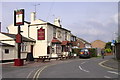
Two cottages off Vine Lane, Warwick
They are appealing and oddly-sited, like a couple of other properties in the backland of Vine Lane and the rear of Green Lane, an unadopted residential road.
Image: © Robin Stott
Taken: 16 Jan 2021
0.06 miles
5
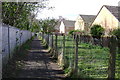
Footpath north of railway, Warwick
Part of National Cycle Network Route 41.
Image: © Robin Stott
Taken: 8 Apr 2009
0.06 miles
6
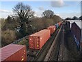
Southbound container freight, Warwick
Freight trains have continued to run, several a day, throughout the pandemic. By now though, the word freight is open to question: the observer is not to know whether these containers are full of exports or whether they are returning to the East empty. The train was perhaps half as long again as that pictured; a number of vacant wagons made up the tail. The view is from the Cape Road bridge.
Image: © Robin Stott
Taken: 9 Feb 2021
0.07 miles
7
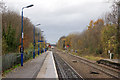
Warwick railway station photo survey (13)
Looking in the down (westbound) direction along platform 1 at Warwick railway station. The staggering of the platforms can be clearly seen in this photo (see below). In the middle distance, a Chiltern Railways service which has just left the station is approaching the bridge carrying Cape Road over the railway.
Warwick station was opened in 1852 by the Great Western railway (GWR) as part of its route from Oxford to Birmingham. It is located approximately half-a-mile from the town centre and appears rather modest for such an historic town.
Today, Warwick station is managed by Chiltern Railways who also operate the majority of the train services although the station is also served by London Midland and CrossCountry.
The main station building and entrance is at the end of Station Road (a driveway from Coventry Road) on the south side of the line. There is also a smaller entrance from Woodcote Road on the north side of the line.
The red brick station building has changed little since its construction and it houses a waiting room, ticket office, staff rooms and a taxi business.
Warwick station's two facing platforms are connected by an underpass. The platforms are staggered slightly and are signalled for bi-directional running. The up platform (for London-bound services) is numbered 2 and the down platform (for Birmingham-bound services) is numbered 1. There is an indoor waiting room in the main building on platform 1 and also small waiting shelters on both platforms.
The station once had extensive goods sidings, a goods shed, a six-ton crane and a coal depot. Goods facilities declined rapidly during the 1950s and 60s and Warwick's goods yard closed in 1969.
Image: © Andy F
Taken: 14 Nov 2009
0.08 miles
8
West end of Green Lane, Warwick
Green Lane is an unadopted road with a boundary to Warwick Hospital.
Image: © Robin Stott
Taken: 16 Jan 2022
0.09 miles
9
Deserted play area, Priory Pools, Warwick
An element of the Covid-19 lockdown was the closure of children's playgrounds. There were no notices to that effect here but there was no-one in sight or hearing. People were being compliant.
Image: © Robin Stott
Taken: 28 Mar 2020
0.09 miles
10
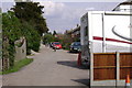
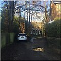
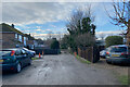
Green Lane, Warwick
Looking back up this private or unadopted road towards Lakin Road.
There is a boundary, left, with Warwick Hospital for most of the length of the road - some 250 metres.
Image: © Robin Stott
Taken: 14 Apr 2009
0.09 miles