
IMAGES TAKEN NEAR TO
Lock Lane, WARWICK, CV34 5AG
Introduction
This page details the photographs taken nearby to Lock Lane, CV34 5AG by members of the Geograph project.
The Geograph project started in 2005 with the aim of publishing, organising and preserving representative images for every square kilometre of Great Britain, Ireland and the Isle of Man.

There are currently over 7.5m images from over14,400 individuals and you can help contribute to the project by visiting https://www.geograph.org.uk
Image Map
Images are licensed for reuse under creativecommons.org/licenses/by-sa/2.0
Notes
- Clicking on the map will re-center to the selected point.
- The higher the marker number, the further away the image location is from the centre of the postcode.
Image Listing (124 Images Found)
Images are licensed for reuse under creativecommons.org/licenses/by-sa/2.0
Image
Details
Distance
1
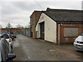
JME Healeys workshop and offices, Lock Lane, Warwick
A brass plaque by the workshop door is headed by the Austin-Healey logo or marque. The text reads:
"This workshop was originally erected by the Donald Healey Motor Co. in 1954 for the building of the Austin Healey 100S (Sebring) and then, following the end of their production, was used for the building of the Healey Sprite boats. It then became the Service and Special Tuning Department until DHMC moved to the 'Old Cinema' on the Emscote Road in 1963."
Below the letters JME the workshop roller shutter bears the legend The Cape Works. Some say this part of Warwick is called the Cape after the old canalside pub The Cape of Good Hope Image The old cinema referred to was in Coten End; the company's name is remembered in the block of retirement flats on the site: Healey Court Image
Image: © Robin Stott
Taken: 29 Mar 2017
0.01 miles
2
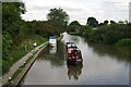
Approaching Cape Bottom Lock, Grand Union Canal, Warwick
The scene appears rural but the reality is otherwise: there's a housing estate to the left, Woodloes Park, and an industrial estate to the right.
Image: © Robin Stott
Taken: 13 Aug 2009
0.02 miles
3
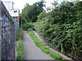
Canal overflow, Cape Locks, Warwick
Water from the pound below Cape Top Lock is channelled to the pound below Cape Bottom Lock - which in fact extends east for at least seven kilometres through Warwick and Leamington to Radford Bottom Lock in Image, where it starts climbing again. This view is from the footpath off the north end of Lock Lane. The lock is out of sight behind the scrub.
Image: © Robin Stott
Taken: 13 Aug 2009
0.02 miles
4
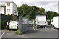
The north end of Lock Lane, Warwick
Premises of 'builders, carpenters and joiners' on the left; a vehicle body repairer on the right. The Grand Union Canal at Cape Bottom Lock is between the back fence and the trees.
Image: © Robin Stott
Taken: 13 Aug 2009
0.02 miles
5
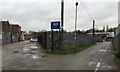
The fork in Lock Lane, The Cape, Warwick
Lock Lane is not a named industrial estate, more a trading estate perhaps, with several companies offering vehicle servicing and repairs. The distant building on the right is beside the canal. Cape Bottom Lock is reached by a footpath.
Image: © Robin Stott
Taken: 29 Mar 2017
0.02 miles
6

Fertile stems of (probably) Common Horsetail, Lock Lane, The Cape, Warwick
Equisetum arvense mixed up with dandelions and grasses. "These stems die back when spores produced in the 'cone' have ripened." As they ripen the familiar green, but sterile, horsetail shoots appear: Image
Image: © Robin Stott
Taken: 29 Mar 2017
0.02 miles
8
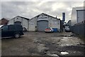
Falcon workshops, Lock Lane, Warwick
Falcon is an established company that does things to cars.
Image: © Robin Stott
Taken: 16 Jan 2021
0.05 miles
9
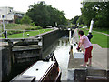
Cape Bottom Lock, Grand Union Canal
Seen from the footbridge to the north of Lock Lane, that links to the Woodloes estate. Cape Top Lock is just visible in the distance.
Image: © Robin Stott
Taken: 13 Aug 2009
0.06 miles
10
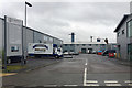
St George's Industrial Park, Lower Cape, Warwick
Lower Cape once had heavy industry: all gone. This is a small industrial estate among extensive new housing whose selling points include being near the canal.
Image: © Robin Stott
Taken: 29 Mar 2017
0.06 miles