IMAGES TAKEN NEAR TO
Coten End, WARWICK, CV34 4NS
Introduction
This page details the photographs taken nearby to Coten End, CV34 4NS by members of the Geograph project.
The Geograph project started in 2005 with the aim of publishing, organising and preserving representative images for every square kilometre of Great Britain, Ireland and the Isle of Man.

There are currently over 7.5m images from over14,400 individuals and you can help contribute to the project by visiting https://www.geograph.org.uk
Image Map
Images are licensed for reuse under creativecommons.org/licenses/by-sa/2.0
Notes
- Clicking on the map will re-center to the selected point.
- The higher the marker number, the further away the image location is from the centre of the postcode.
Image Listing (730 Images Found)
Images are licensed for reuse under creativecommons.org/licenses/by-sa/2.0
Image
Details
Distance
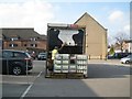
1
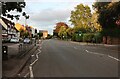
Recent convenience store, Coten End, Warwick
This site was a derelict petrol filling station for many years, with an active vehicle servicing business behind it. The shops in the redevelopment were vacant for a long time. Then in 2011 perhaps, a Sainsbury's Local store opened alongside a Wickes kitchen and bathroom showroom, with flats above. Before long two family businesses across the road had closed, a convenience store Image and a greengrocer, much missed Image
Image: © Robin Stott
Taken: 22 Jul 2012
0.01 miles
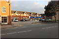
2
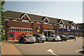
Coten End, Warwick
Seen from the end of Coten End Image
The 18th century tower of St Mary's Church on the skyline. The half-timbered building is the Millwright Arms public house.
Image: © Robin Stott
Taken: 21 Mar 2009
0.01 miles
3
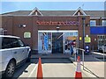
Entrance, Sainsbury's Local, Coten End, Warwick, during the pandemic
Restrictions remain in place: so many notices!
Image: © Robin Stott
Taken: 1 Jun 2021
0.01 miles
4
Delivering milk to a Sainsbury's Local store, Coten End, Warwick
Time: 09:45 on a sunny Saturday morning in mid-March. In Birmingham later in the morning (for Geograph's 10th birthday meet in the Midlands) it turned dull, misty and cold.
Image: © Robin Stott
Taken: 14 Mar 2015
0.01 miles
6
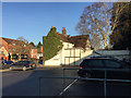
Extended timber-framed house next to Sainsbury's Local, 24 Coten End, Warwick
Listed Grade II. The south side glimpsed here is attributed to 1781. The main façade facing the street is "probably early C18 brickwork". HE List entry number 1364819.
The Sainsbury's site was formerly a petrol station. The store is in addition to two huge supermarkets: one near Warwick Racecourse, the other on the Leamington Retail Park off Tachbrook Park Drive, south Leamington, as well as other Local stores.
Image: © Robin Stott
Taken: 1 Dec 2016
0.02 miles
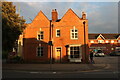
8
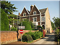
28 (right) and 30, Coten End, Warwick
Imposing Victorian houses with long front gardens. On the right is the main entrance to Coten End Primary School, formerly First School.
Image: © Robin Stott
Taken: 22 Jul 2012
0.02 miles
9
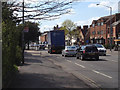
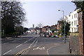
Westbound traffic in Coten End, Warwick
Apart from the traffic, Coten End is a pleasant wide street of mixed uses, including houses, and a range of building types of different ages.
Image: © Robin Stott
Taken: 14 Apr 2014
0.03 miles