IMAGES TAKEN NEAR TO
Guys Cliffe Terrace, WARWICK, CV34 4LP
Introduction
This page details the photographs taken nearby to Guys Cliffe Terrace, CV34 4LP by members of the Geograph project.
The Geograph project started in 2005 with the aim of publishing, organising and preserving representative images for every square kilometre of Great Britain, Ireland and the Isle of Man.

There are currently over 7.5m images from over14,400 individuals and you can help contribute to the project by visiting https://www.geograph.org.uk
Image Map
Images are licensed for reuse under creativecommons.org/licenses/by-sa/2.0
Notes
- Clicking on the map will re-center to the selected point.
- The higher the marker number, the further away the image location is from the centre of the postcode.
Image Listing (551 Images Found)
Images are licensed for reuse under creativecommons.org/licenses/by-sa/2.0
Image
Details
Distance
1
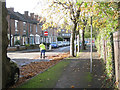
Sweeping up leaves, Guy's Cliffe Terrace
A council contractor in the road sweeps up wet-looking leaves blown off the footway by a colleague Image
Image: © Robin Stott
Taken: 30 Oct 2012
0.01 miles
2
North on Cherry Street, Warwick
Cherry Street is the middle one of three residential streets to the north of Coten End.
Image: © Robin Stott
Taken: 16 May 2014
0.02 miles
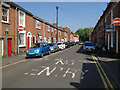
3
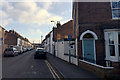
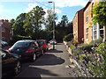
Guy's Cliffe Terrace, Warwick
A pleasant street despite facing north and being so close to a busy railway.
The house at the end is in Broad Street. These streets are part of National Cycle Network Route 41.
Image: © Robin Stott
Taken: 24 Mar 2009
0.03 miles
4
Station Avenue, Warwick
Station Avenue, left. Private drive to office and depot of a building contractor, right, and having all the appearance of former railway land: a coal yard, perhaps.
Image: © Robin Stott
Taken: 3 Apr 2009
0.03 miles
5
Southeast on Cherry Street, Warwick
Cherry Street meets Coten End. The view is from Guy's Cliffe Terrace. A one-way system here and in parallel streets allows parking for residents but not commuters travelling from nearby Warwick Station.
Image: © Robin Stott
Taken: 26 Nov 2016
0.03 miles
6
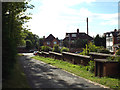
West down the former goods yard approach road, off Station Avenue, Warwick
The view is towards Coventry Road from the gate to Baxi's Acorn House Training Centre: Image The stepped wall is presumed to date from the GWR era.
Image: © Robin Stott
Taken: 9 Aug 2015
0.04 miles
7
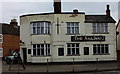
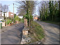
The Railway, Warwick
Unlike the nearby Great Western, this pub is still open. However, it does not look much more inviting.
Image: © Robert Eva
Taken: 28 Oct 2016
0.04 miles
8
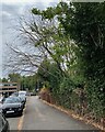
West on Guy's Cliffe Terrace, Warwick
The vegetation on the right is on a railway embankment. A dead tree hangs over the footway. It was Goat Willow or Pussy Willow (Salix caprea), a glorious sight in early spring.
Image: © Robin Stott
Taken: 28 Jul 2022
0.04 miles
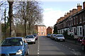
9
North end of Broad Street, Warwick
The street turns sharply left into Guy's Cliffe Terrace. The railway runs on an embankment behind the trees. The three-storey house, upper right, is an exception among pleasant two-storey terraces.
Image: © Robin Stott
Taken: 9 Aug 2015
0.04 miles
10
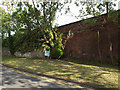
Retaining walls by Station Avenue, Warwick
The brick wall supporting the railway is the extension of the flank wall to the Coventry Road railway bridge. The walls of local sandstone must have supported part of the goods; they have been repaired in places with engineering brick. The sign directs visitors up the private drive to Baxi's Acorn House Training Centre: Image An aerial photo shows more vegetation than this.
Image: © Robin Stott
Taken: 9 Aug 2015
0.05 miles