IMAGES TAKEN NEAR TO
Coventry Road, WARWICK, CV34 4LJ
Introduction
This page details the photographs taken nearby to Coventry Road, CV34 4LJ by members of the Geograph project.
The Geograph project started in 2005 with the aim of publishing, organising and preserving representative images for every square kilometre of Great Britain, Ireland and the Isle of Man.

There are currently over 7.5m images from over14,400 individuals and you can help contribute to the project by visiting https://www.geograph.org.uk
Image Map
Images are licensed for reuse under creativecommons.org/licenses/by-sa/2.0
Notes
- Clicking on the map will re-center to the selected point.
- The higher the marker number, the further away the image location is from the centre of the postcode.
Image Listing (682 Images Found)
Images are licensed for reuse under creativecommons.org/licenses/by-sa/2.0
Image
Details
Distance
1
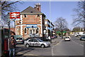
The Great Western, Coventry Road, Warwick
Another view. Station Road, left.
Image: © Robin Stott
Taken: 24 Mar 2009
0.01 miles
2
Coventry Road, Warwick
Looking south towards St John's and in the general direction of the castle.
Image: © Robin Stott
Taken: 19 Apr 2009
0.01 miles
3
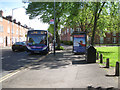
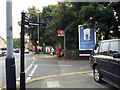
Bus stop, Coventry Road by Priory Park, Warwick
A pleasant group of common lime trees overhangs the bus shelter. The X17 service from Coventry is on its way to Warwick Hospital and the town centre. How one tires of inane faces on the fronts of vehicles.
Image: © Robin Stott
Taken: 11 May 2015
0.01 miles
4
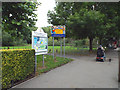
Coventry Road entrance to Priory Park, Warwick
This is also the main access to Warwick Children's Centre and Nursery School, formerly plain Warwick Nursery School, and still provided by Warwickshire County Council. The bus stop up the road is for the useful and frequent X17 service by Stagecoach.
Image: © Robin Stott
Taken: 13 Sep 2013
0.01 miles
5
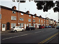
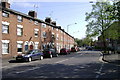
Three-storey terrace, Coventry Road, Warwick
Pairs of doors alternate with pairs of windows, all much altered. These houses are shown on the 1887 Ordnance Survey town plan; could they be early nineteenth century?
Image: © Robin Stott
Taken: 28 Aug 2013
0.02 miles
7
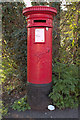
Junction of Station Road and Coventry Road, Warwick
The Great Western pub is immediately behind the camera Image Postbox number CV34 125.
Image: © Robin Stott
Taken: 28 Aug 2013
0.02 miles
8
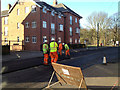
Resurfacing Coventry Road, Warwick
The old surface has been planed off and removed. New bituminous aggregate is being laid (sounds knowledgeable but I have no idea if it's right. Could be asphalt?). The view is across the road to Woodville Court, recent flats on the site of a VW showroom and service centre. On the right is the east side of Priory Park.
Image: © Robin Stott
Taken: 19 Feb 2013
0.03 miles
9
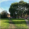
Desire line for pushchairs, Warwick
This well-worn track runs between Coventry Road and the Nursery School behind the camera. Parents bring and fetch their children often with younger ones in buggies.
Photo number 7647622.
Image: © Robin Stott
Taken: 9 Oct 2023
0.03 miles
10
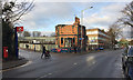
Corner of Station Road and Coventry Road, Warwick
The wreck of the burnt-out Great Western pub is slowly deteriorating. Last photographed in November: Image Baxi's premises extend behind it on both sides, obscuring Warwick station.
Image: © Robin Stott
Taken: 15 Dec 2017
0.03 miles