
IMAGES TAKEN NEAR TO
Gerrard Street, WARWICK, CV34 4HD
Introduction
This page details the photographs taken nearby to Gerrard Street, CV34 4HD by members of the Geograph project.
The Geograph project started in 2005 with the aim of publishing, organising and preserving representative images for every square kilometre of Great Britain, Ireland and the Isle of Man.

There are currently over 7.5m images from over14,400 individuals and you can help contribute to the project by visiting https://www.geograph.org.uk
Image Map
Images are licensed for reuse under creativecommons.org/licenses/by-sa/2.0
Notes
- Clicking on the map will re-center to the selected point.
- The higher the marker number, the further away the image location is from the centre of the postcode.
Image Listing (1357 Images Found)
Images are licensed for reuse under creativecommons.org/licenses/by-sa/2.0
Image
Details
Distance
1
![Warwick houses [31]](https://s2.geograph.org.uk/geophotos/06/59/18/6591854_d0423214_120x120.jpg)
Warwick houses [31]
Numbers 11, 13 and 15 Gerrard Street were built in the late 18th century in red brick. Listed, grade II, with details at: https://historicengland.org.uk/listing/the-list/list-entry/1035461
A market town and county town of Warwickshire, Warwick lies on the River Avon, 11 miles (18 kilometres) south of Coventry. There is evidence of unbroken habitation from the 6th century AD with signs of Neolithic and Roman activity before that date. It was a Saxon burh in the 9th century and Warwick Castle was built during the Norman Conquest. Much of the town was destroyed in The Great Fire of Warwick in 1694. Warwick Racecourse is located just west of the town centre. The Grand Union Canal passes through the town and the restored Saltisford Canal Arm is close to the town centre.
Image: © Michael Dibb
Taken: 7 Aug 2020
0.01 miles
2
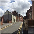
Summit of Gerrard Street, Warwick
On the left is the gated car park to Goodway Court, infill properties behind the north side of St Nicholas Church Street. On the right no.2 is a fairly new house. Note, lower right, the kerbstones change from concrete to a dark blue-grey whinstone or basalt.
Image: © Robin Stott
Taken: 11 Jul 2019
0.01 miles
3
![Warwick houses [30]](https://s1.geograph.org.uk/geophotos/06/59/08/6590845_e1a8bfcb_120x120.jpg)
Warwick houses [30]
This one house with two numbers, 7 and 9 Gerrard Street, is the remaining part of a range of four cottages. Built in the first half of the 17th century, the building was refronted in brick in the late 19th century and the roof raised at the front. The adjoining cottages were demolished circa 1970 and the remaining two cottages converted to a single dwelling sometime in the 20th century. There are some original internal features. Listed, grade II, with details at: https://historicengland.org.uk/listing/the-list/list-entry/1449963
A market town and county town of Warwickshire, Warwick lies on the River Avon, 11 miles (18 kilometres) south of Coventry. There is evidence of unbroken habitation from the 6th century AD with signs of Neolithic and Roman activity before that date. It was a Saxon burh in the 9th century and Warwick Castle was built during the Norman Conquest. Much of the town was destroyed in The Great Fire of Warwick in 1694. Warwick Racecourse is located just west of the town centre. The Grand Union Canal passes through the town and the restored Saltisford Canal Arm is close to the town centre.
Image: © Michael Dibb
Taken: 7 Aug 2020
0.01 miles
4
![Warwick houses [32]](https://s3.geograph.org.uk/geophotos/06/59/18/6591855_9d0cd116_120x120.jpg)
Warwick houses [32]
Number 17 Gerrard Street is late 18th century in red brick with an extension on the right. Some window openings have been blocked. Reputedly built for Charles Perceval when MP for Warwick 1790-96. Listed, grade II, with details at: https://historicengland.org.uk/listing/the-list/list-entry/1184355
A market town and county town of Warwickshire, Warwick lies on the River Avon, 11 miles (18 kilometres) south of Coventry. There is evidence of unbroken habitation from the 6th century AD with signs of Neolithic and Roman activity before that date. It was a Saxon burh in the 9th century and Warwick Castle was built during the Norman Conquest. Much of the town was destroyed in The Great Fire of Warwick in 1694. Warwick Racecourse is located just west of the town centre. The Grand Union Canal passes through the town and the restored Saltisford Canal Arm is close to the town centre.
Image: © Michael Dibb
Taken: 7 Aug 2020
0.01 miles
5
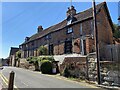
4-6 Gerrard Street, Warwick
Grade II listed https://historicengland.org.uk/listing/the-list/list-entry/1364822?section=official-list-entry
Image: © Robin Stott
Taken: 5 Jun 2021
0.01 miles
6
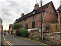
Nos 4 and 6 Gerrard Street, Warwick
A pair of timber-framed brick houses on a plinth. Historic England list entry 1364822 says 1. 1781; 2. First half of C16; listed grade II https://historicengland.org.uk/listing/the-list/list-entry/1364822
Image: © Robin Stott
Taken: 5 Nov 2018
0.02 miles
7
![Warwick houses [29]](https://s0.geograph.org.uk/geophotos/06/59/08/6590844_8282337a_120x120.jpg)
Warwick houses [29]
Number 4 (nearest the camera) and number 6 Gerrard Street were built in the first half of the 16th century. Heavy rectangular timber framing with early red brick noggin. Listed, grade II, with details at: https://historicengland.org.uk/listing/the-list/list-entry/1364822
A market town and county town of Warwickshire, Warwick lies on the River Avon, 11 miles (18 kilometres) south of Coventry. There is evidence of unbroken habitation from the 6th century AD with signs of Neolithic and Roman activity before that date. It was a Saxon burh in the 9th century and Warwick Castle was built during the Norman Conquest. Much of the town was destroyed in The Great Fire of Warwick in 1694. Warwick Racecourse is located just west of the town centre. The Grand Union Canal passes through the town and the restored Saltisford Canal Arm is close to the town centre.
Image: © Michael Dibb
Taken: 7 Aug 2020
0.02 miles
8
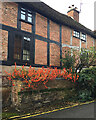
Chinese Lanterns (Physalis species) in Gerrard Street, Warwick
Confined to a raised bed they can spread to their heart's content and cheer up a street that is often in shade. Nos 4-6 Gerrard Street are listed Image
Image: © Robin Stott
Taken: 7 Dec 2019
0.02 miles
9

Gerrard Street, Warwick
A quiet street displaying a chance harmony of brick, timber, and stone.
Photo number 8116147.
Image: © Robin Stott
Taken: 7 Jun 2025
0.02 miles
10
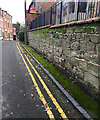
Gerrard Street, Warwick ? kerb of dark grey stone
To be identified.
Image: © Robin Stott
Taken: 7 Dec 2019
0.02 miles