
IMAGES TAKEN NEAR TO
Castle Lane, WARWICK, CV34 4BU
Introduction
This page details the photographs taken nearby to Castle Lane, CV34 4BU by members of the Geograph project.
The Geograph project started in 2005 with the aim of publishing, organising and preserving representative images for every square kilometre of Great Britain, Ireland and the Isle of Man.

There are currently over 7.5m images from over14,400 individuals and you can help contribute to the project by visiting https://www.geograph.org.uk
Image Map
Images are licensed for reuse under creativecommons.org/licenses/by-sa/2.0
Notes
- Clicking on the map will re-center to the selected point.
- The higher the marker number, the further away the image location is from the centre of the postcode.
Image Listing (1533 Images Found)
Images are licensed for reuse under creativecommons.org/licenses/by-sa/2.0
Image
Details
Distance
1
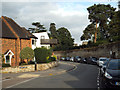
Junction of Castle Lane and Back Lane, Warwick
Back Lane heads for High Street, lower left. Castle Lane continues along the walls of the Castle grounds, which display some splendid evergreen trees. No.18, the white modern house, has a fine view of them; it was for sale at the time of the photo.
Image: © Robin Stott
Taken: 20 Sep 2013
0.02 miles
2
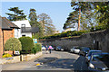
Castle Lane
A relatively quiet residential road following the castle wall. A couple of towers are just visible over the wall.
Image: © Bill Boaden
Taken: 19 Apr 2019
0.02 miles
3
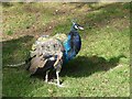
A peacock, Warwick Castle
One of several resident birds to be seen in the castle grounds.
Image: © pam fray
Taken: 17 Oct 2023
0.02 miles
4
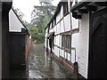
A wet August afternoon in Warwick
The alley behind Oken's House, and torrential rain.
Image: © John Sutton
Taken: 29 Aug 2012
0.03 miles
5
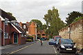
Cyclist on Castle Lane, Warwick
At the end of the street is a double bend after which Castle Lane continues through to Castle Hill. The wall of the Castle grounds is on the right. There is a gate in it by the birch trees, right of centre, long sought by businesses in the town and the council, the hope being that visitors to the Castle would venture into the town and spend some money.
Image: © Robin Stott
Taken: 20 Sep 2013
0.03 miles
6
![Warwick houses [20]](https://s2.geograph.org.uk/geophotos/06/58/97/6589726_6a995547_120x120.jpg)
Warwick houses [20]
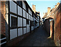
Originally a range of 3 cottages now two, Numbers 12 and 16 Castle Street are probably 16th century, timber framed with brick nogging. Listed, grade II, with details at: https://historicengland.org.uk/listing/the-list/list-entry/1035484
A market town and county town of Warwickshire, Warwick lies on the River Avon, 11 miles (18 kilometres) south of Coventry. There is evidence of unbroken habitation from the 6th century AD with signs of Neolithic and Roman activity before that date. It was a Saxon burh in the 9th century and Warwick Castle was built during the Norman Conquest. Much of the town was destroyed in The Great Fire of Warwick in 1694. Warwick Racecourse is located just west of the town centre. The Grand Union Canal passes through the town and the restored Saltisford Canal Arm is close to the town centre.
Image: © Michael Dibb
Taken: 7 Aug 2020
0.03 miles
8
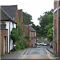
Back Lane
A slightly foreshortened zoom view towards the Castle from High Street.
Image: © John Sutton
Taken: 29 Aug 2012
0.03 miles
9
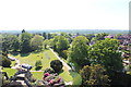
Warwick Castle (59)
This photograph Image shows another view of Warwick Castles grounds.
Image: © Chris' Buet
Taken: 6 Jun 2013
0.03 miles
10
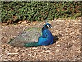
Peacock, Warwick Castle
One of several resident birds in the castle grounds. Warwick Castle is a medieval castle developed from a wooden fort, originally built by William the Conqueror during 1068. The original wooden motte-and-bailey castle was rebuilt in stone during the 12th century. During the Hundred Years War, the facade opposite the town was refortified. It was used as a stronghold until the early 17th century, when it was granted to Sir Fulke Greville by James I in 1604. Greville converted it to a country house, and it was owned by the Greville family until 1978, when it was bought by the Tussauds Group.
Image: © pam fray
Taken: 17 Oct 2023
0.03 miles