IMAGES TAKEN NEAR TO
Priory Road, WARWICK, CV34 4AE
Introduction
This page details the photographs taken nearby to Priory Road, CV34 4AE by members of the Geograph project.
The Geograph project started in 2005 with the aim of publishing, organising and preserving representative images for every square kilometre of Great Britain, Ireland and the Isle of Man.

There are currently over 7.5m images from over14,400 individuals and you can help contribute to the project by visiting https://www.geograph.org.uk
Image Map
Images are licensed for reuse under creativecommons.org/licenses/by-sa/2.0
Notes
- Clicking on the map will re-center to the selected point.
- The higher the marker number, the further away the image location is from the centre of the postcode.
Image Listing (985 Images Found)
Images are licensed for reuse under creativecommons.org/licenses/by-sa/2.0
Image
Details
Distance
1
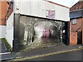
Workshop doors, Cross Street, Warwick
Formerly it housed a backstreet car maintenance business.
Image: © Robin Stott
Taken: 6 Nov 2022
0.02 miles
2
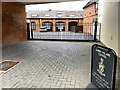
Sorry, Museum closed, Priory Road, Warwick
Offices in a former drill hall Image have become The Museum of the Queen's Royal Hussars (Churchill's own regiment).
Image: © Robin Stott
Taken: 8 Sep 2022
0.02 miles
3
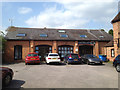
Former First World War Drill Hall, rear of Priory Road, Warwick
Although a substantial former house fronting Priory Road, behind and to the right of the camera, calls itself 'The Old Drill Hall', this building to the north of it looks more like a drill hall. People working in the building certainly believed that it had been. It first appears on OS 1:2500 County Series maps dated 1913-27. It seems reasonable to surmise that it was built around the start of World War I. Its current address is No.2 Trinity Mews, Priory Road, Warwick CV34 4NA, and is home to a couple of businesses. A first floor has been inserted – the reason for the rooflights. Nothing else is known at the time of writing (July 2014). Earlier maps show a group of buildings around a courtyard garden with a fountain at its centre and glasshouses on its north side.
Don Funnell writes, 10 Jan 2016: "yes it was a drill hall at least until the 1960s. My father was a military person there in the 1950s. There was even a .22 rifle range on the site."
Update: September 2022. The property has opened as the Museum of the Queen's Royal Hussars (Churchill's own regiment) Image
Image: © Robin Stott
Taken: 30 Jul 2014
0.03 miles
4
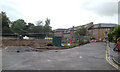
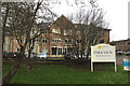
Site of Park View care home, off Priory Road, Warwick
Runwood Homes will be rebuilding their Park View care home http://www.runwoodhomes.co.uk/product.php/63/park_view_warwickshire The range of sheltered accommodation in Yeomanry Close, right, is owned and managed by Warwick District Council http://www.housingcare.org/housing-care/facility-info-36286-yeomanry-close-priory-road-england.aspx
Update 2017: Image
Image: © Robin Stott
Taken: 19 Jul 2014
0.03 miles
5
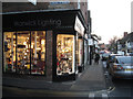
Lighting shop, corner of Cross Street and Smith Street
This business has managed to survive, unlike others nearby Image
Image: © Robin Stott
Taken: 1 Dec 2012
0.03 miles
7
New accommodation at Park View, Priory Road, Warwick
A sign by Runwood Homes announces Senior Living at the rebuilt Park View. It's a private residential care home https://www.runwoodhomes.co.uk/homes/park-view-warwickshire The site adjoins Warwick District Council sheltered housing in Yeomanry Close, partly seen on the right and last photographed in July 2014: Image
Image: © Robin Stott
Taken: 23 Dec 2017
0.03 miles
8
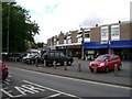
Shops, St John's, Warwick
At a 5-way junction these shops have an above-average number of take-aways and a large off-licence. Frenetic in early evening.
Image: © Robin Stott
Taken: 13 Jul 2009
0.03 miles
9
![Warwick buildings [90]](https://s1.geograph.org.uk/geophotos/06/61/67/6616705_1f310576_120x120.jpg)
Warwick buildings [90]
Numbers 55 and 55A Smith Street are in this late 16th century timber framed house with twin gables. The plate glass shopfronts are modern. Listed, grade II, with details at: https://historicengland.org.uk/listing/the-list/list-entry/1185260
A market town and county town of Warwickshire, Warwick lies on the River Avon, 11 miles (18 kilometres) south of Coventry. There is evidence of unbroken habitation from the 6th century AD with signs of Neolithic and Roman activity before that date. It was a Saxon burh in the 9th century and Warwick Castle was built during the Norman Conquest. Much of the town was destroyed in The Great Fire of Warwick in 1694. Warwick Racecourse is located just west of the town centre. The Grand Union Canal passes through the town and the restored Saltisford Canal Arm is close to the town centre.
Image: © Michael Dibb
Taken: 6 Aug 2020
0.03 miles
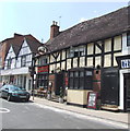
10
![Warwick buildings [92]](https://s1.geograph.org.uk/geophotos/06/61/67/6616709_18279893_120x120.jpg)
Warwick buildings [92]
This late 15th century building (1470), much restored, houses number 57, The Roebuck Inn, and 57A Smith Street. The shop on the right has the framing covered in stucco and a modern plate glass shop front. Listed, grade II, with details at: https://historicengland.org.uk/listing/the-list/list-entry/1364859
A market town and county town of Warwickshire, Warwick lies on the River Avon, 11 miles (18 kilometres) south of Coventry. There is evidence of unbroken habitation from the 6th century AD with signs of Neolithic and Roman activity before that date. It was a Saxon burh in the 9th century and Warwick Castle was built during the Norman Conquest. Much of the town was destroyed in The Great Fire of Warwick in 1694. Warwick Racecourse is located just west of the town centre. The Grand Union Canal passes through the town and the restored Saltisford Canal Arm is close to the town centre.
Image: © Michael Dibb
Taken: 6 Aug 2020
0.03 miles