IMAGES TAKEN NEAR TO
Wychwood Close, LEAMINGTON SPA, CV33 9QU
Introduction
This page details the photographs taken nearby to Wychwood Close, CV33 9QU by members of the Geograph project.
The Geograph project started in 2005 with the aim of publishing, organising and preserving representative images for every square kilometre of Great Britain, Ireland and the Isle of Man.

There are currently over 7.5m images from over14,400 individuals and you can help contribute to the project by visiting https://www.geograph.org.uk
Image Map (Loading...)


Getting Data...Please wait
Leaflet Map data © OpenStreetMap
Images are licensed for reuse under creativecommons.org/licenses/by-sa/2.0
Notes
- Clicking on the map will re-center to the selected point.
- The higher the marker number, the further away the image location is from the centre of the postcode.
Image Listing (37 Images Found)
Images are licensed for reuse under creativecommons.org/licenses/by-sa/2.0
Image
Details
Distance
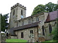
1
Bishop's Tachbrook
St Chad's church, in the centre of the village
Image: © David Stowell
Taken: 28 May 2005
0.01 miles
2
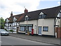
Bishop's Tachbrook
The Village Stores and Post Office, sadly no longer in business and subject of a planning application for conversion into a private dwelling
Image: © David Stowell
Taken: 28 May 2005
0.01 miles
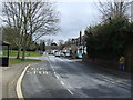
3
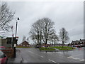
Junction of Mallory Road and Church Lees
Image: © Basher Eyre
Taken: 8 Feb 2019
0.03 miles
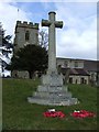

7

St Chad, Bishop's Tachbrook: war memorial
Image: © Basher Eyre
Taken: 8 Feb 2019
0.05 miles
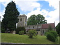
8
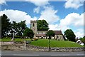
Bishop's Tachbrook Church
St Chad's on an elevated position in the village.
Image: © Ian Rob
Taken: 20 Jun 2016
0.05 miles
9

St Chad, Bishop's Tachbrook: grave stones
Image: © Basher Eyre
Taken: 8 Feb 2019
0.06 miles