IMAGES TAKEN NEAR TO
Southam Road, LEAMINGTON SPA, CV33 9PP
Introduction
This page details the photographs taken nearby to Southam Road, CV33 9PP by members of the Geograph project.
The Geograph project started in 2005 with the aim of publishing, organising and preserving representative images for every square kilometre of Great Britain, Ireland and the Isle of Man.

There are currently over 7.5m images from over14,400 individuals and you can help contribute to the project by visiting https://www.geograph.org.uk
Image Map
Images are licensed for reuse under creativecommons.org/licenses/by-sa/2.0
Notes
- Clicking on the map will re-center to the selected point.
- The higher the marker number, the further away the image location is from the centre of the postcode.
Image Listing (4 Images Found)
Images are licensed for reuse under creativecommons.org/licenses/by-sa/2.0
Image
Details
Distance
1
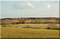
Farmland near the A425 with Harbury landfill site in the distance
Image: © Andy F
Taken: 4 Nov 2009
0.11 miles

3
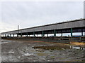
Cattle Barn at Ufton Hill Farm
This long open sided barn held a large number of cattle, being fed from fedd stalls along the side of the building.
Image: © Nigel Mykura
Taken: 19 Nov 2012
0.23 miles