IMAGES TAKEN NEAR TO
Chesterton Road, LEAMINGTON SPA, CV33 9NJ
Introduction
This page details the photographs taken nearby to Chesterton Road, CV33 9NJ by members of the Geograph project.
The Geograph project started in 2005 with the aim of publishing, organising and preserving representative images for every square kilometre of Great Britain, Ireland and the Isle of Man.

There are currently over 7.5m images from over14,400 individuals and you can help contribute to the project by visiting https://www.geograph.org.uk
Image Map (Loading...)


Getting Data...Please wait
Leaflet Map data © OpenStreetMap
Images are licensed for reuse under creativecommons.org/licenses/by-sa/2.0
Notes
- Clicking on the map will re-center to the selected point.
- The higher the marker number, the further away the image location is from the centre of the postcode.
Image Listing (6 Images Found)
Images are licensed for reuse under creativecommons.org/licenses/by-sa/2.0
Image
Details
Distance
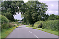
3
Ranch House on Windmill Hill
The view from the road.
Image: © Ian Rob
Taken: 12 Apr 2014
0.22 miles
4
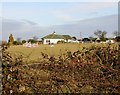
Ranch House from Chesterton Road
View NE over field to Ranch House near Harbury.
Image: © David P Howard
Taken: 24 Jan 2010
0.22 miles
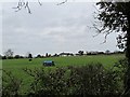
5
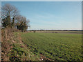
Near Windmill Hill
Farmland between Chesterton Green and Harbury.
Image: © Dennis Turner
Taken: 17 Dec 2005
0.24 miles