IMAGES TAKEN NEAR TO
Windmill Hill Lane, LEAMINGTON SPA, CV33 9LB
Introduction
This page details the photographs taken nearby to Windmill Hill Lane, CV33 9LB by members of the Geograph project.
The Geograph project started in 2005 with the aim of publishing, organising and preserving representative images for every square kilometre of Great Britain, Ireland and the Isle of Man.

There are currently over 7.5m images from over14,400 individuals and you can help contribute to the project by visiting https://www.geograph.org.uk
Image Map (Loading...)


Getting Data...Please wait
Leaflet Map data © OpenStreetMap
Images are licensed for reuse under creativecommons.org/licenses/by-sa/2.0
Notes
- Clicking on the map will re-center to the selected point.
- The higher the marker number, the further away the image location is from the centre of the postcode.
Image Listing (8 Images Found)
Images are licensed for reuse under creativecommons.org/licenses/by-sa/2.0
Image
Details
Distance
1
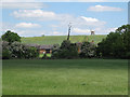
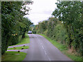
A glimpse of Windmill Farm
A gap in the hedgerow reveals one of two converted barns, with the old farmhouse to the right. Some sizeable farm buildings are hidden. Inigo Jones's Chesterton Windmill looks on from Windmill Hill. Photo taken from a little northeast of the point where the bridleway clips the corner of the square.
Image: © Robin Stott
Taken: 28 May 2010
0.03 miles
2
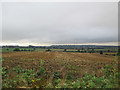
A view from Chesterton Windmill
Looking west south-west towards the Fosse Way on a rainy September afternoon. The red-brick houses in the middle distance, to the right of centre, are Field Farm Cottages. Windmill Hill Farm is straight ahead, but hidden at the bottom of the hill.
Image: © John Sutton
Taken: 10 Sep 2016
0.17 miles
3
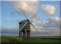
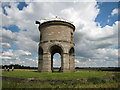
Chesterton Windmill
Built in 1632, now restored. Situated in a field of oilseed rape.
Image: © Richard Webb
Taken: 19 May 2004
0.20 miles
4
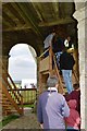
Chesterton Mill - Ground Level
The mill is raised off the ground on six columns with connecting arches. Stairs give access directly to the Stone Floor. Until 1930 there was a square timber structure from ground level to the underside of the Stone Floor used for grain storage but removed to prevent vandalism.
Image: © John M
Taken: 15 May 2016
0.20 miles
6

Chesterton Windmill
Seen from the south. This is sometimes claimed to be England's most unusual windmill since it was designed as an architectural landmark as much as a functioning mill. The current machinery dates from 1860 and was used until about 1910 before gradually becoming derelict. The mill was restored to working order between 1965 and 1971 and is now owned by Warwickshire County Council. Open days are held for members of the public to visit the mill, although these had to cancelled during the early part of 2001 when the windmill lost two of its sails in a storm. As can be seen from the picture these have now been repaired.
Image: © David Stowell
Taken: 23 Dec 2005
0.24 miles
7
Chesterton Windmill - without sails
In an unfortunate accident during an open day on September 2006 one of the sails fell off, slightly injuring a woman standing nearby. The rest of the sails have since been removed for investigation and repair.
Image: © David Stowell
Taken: 7 Jul 2007
0.24 miles
8
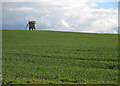
Chesterton Windmill and Windmill Hill
The picture was taken over a field gate during a sunny spell early on a showery April evening. The limestone tower dates from 1632 - for more about it, try http://www2.warwick.ac.uk/fac/sci/moac/people/students/peter_cock/photos/chesterton_windmill/ .
Image: © John Sutton
Taken: 16 Apr 2016
0.24 miles