IMAGES TAKEN NEAR TO
Vicarage Lane, LEAMINGTON SPA, CV33 9HA
Introduction
This page details the photographs taken nearby to Vicarage Lane, CV33 9HA by members of the Geograph project.
The Geograph project started in 2005 with the aim of publishing, organising and preserving representative images for every square kilometre of Great Britain, Ireland and the Isle of Man.

There are currently over 7.5m images from over14,400 individuals and you can help contribute to the project by visiting https://www.geograph.org.uk
Image Map (Loading...)


Getting Data...Please wait
Leaflet Map data © OpenStreetMap
Images are licensed for reuse under creativecommons.org/licenses/by-sa/2.0
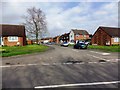
Notes
- Clicking on the map will re-center to the selected point.
- The higher the marker number, the further away the image location is from the centre of the postcode.
Image Listing (35 Images Found)
Images are licensed for reuse under creativecommons.org/licenses/by-sa/2.0
Image
Details
Distance
2
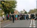
Remembrance Day Parade, Harbury
Villagers taking silence
Image: © Alan Spencer
Taken: 12 Nov 2006
0.07 miles
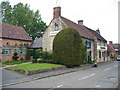
4
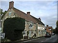
Harbury-The Crown Inn
Public House on Crown Street.
Image: © Ian Rob
Taken: 23 Oct 2010
0.08 miles
5
Harbury
The Crown, near to the Church.
Image: © David Stowell
Taken: 24 May 2005
0.08 miles
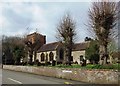
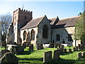
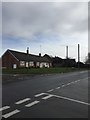
8
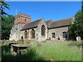
All Saints Church
Harbury parish church in Church Road at the extreme northern edge of the grid square.
Image: © Dennis Turner
Taken: 14 Mar 2007
0.09 miles
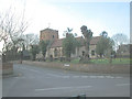
10
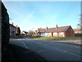
Ancient & Modern
Contrasting house styles in the southern half of Harbury village.
Image: © Dennis Turner
Taken: 17 Dec 2005
0.11 miles