IMAGES TAKEN NEAR TO
Long Itchington Road, LEAMINGTON SPA, CV33 9EN
Introduction
This page details the photographs taken nearby to Long Itchington Road, CV33 9EN by members of the Geograph project.
The Geograph project started in 2005 with the aim of publishing, organising and preserving representative images for every square kilometre of Great Britain, Ireland and the Isle of Man.

There are currently over 7.5m images from over14,400 individuals and you can help contribute to the project by visiting https://www.geograph.org.uk
Image Map (Loading...)


Getting Data...Please wait
Leaflet Map data © OpenStreetMap
Images are licensed for reuse under creativecommons.org/licenses/by-sa/2.0
Notes
- Clicking on the map will re-center to the selected point.
- The higher the marker number, the further away the image location is from the centre of the postcode.
Image Listing (15 Images Found)
Images are licensed for reuse under creativecommons.org/licenses/by-sa/2.0
Image
Details
Distance
1
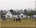
Hunningham Meadows
'Hunningham Meadows' is the name of this large bungalow with loose boxes and paddocks at Hunningham Hill.
Image: © Andy F
Taken: 8 Jan 2009
0.02 miles
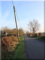
2
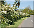
May blossom near Hunningham Hill
Looking north along Long Itchington Road with the may in full blossom.
Image: © Andy F
Taken: 12 May 2009
0.08 miles
3
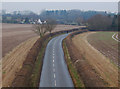
The lane to Hunningham Hill
Looking north along the lane from Long Itchington to Hunningham Hill. The photo was taken from the disused railway bridge.
Image: © Andy F
Taken: 7 Jan 2009
0.13 miles
4
Hunningham House driveway
Looking west along the drive to Hunningham House Farm towards the public road.
Image: © Andy F
Taken: 12 May 2009
0.14 miles
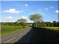
5
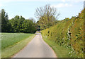
Lane to Snowford Bridge
Looking SSE down the lane from Hunningham Hill towards Snowford Bridge.
Image: © David P Howard
Taken: 13 Nov 2011
0.15 miles
6
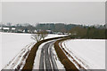
Lane to Hunningham Hill in the snow
Looking north along the lane from Long Itchington to Hunningham Hill. The photo was taken from the disused railway bridge. See also http://www.geograph.org.uk/photo/1111740 .
Image: © Andy F
Taken: 11 Jan 2010
0.15 miles
7

Hunningham Hill (2)
The approach to Hunningham Hill from the southwest. At the top of the rise the lane crosses the Fosse Way (see http://www.geograph.org.uk/photo/9342 for a photo of the crossroads).
Image: © Andy F
Taken: 8 Jan 2009
0.16 miles
8
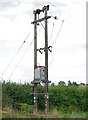
Transformer on Long Itchington Road southeast of Hunningham Hill
Image: © Andy F
Taken: 7 Aug 2009
0.17 miles
9
Woodcote
The road from Hunningham to Long Itchington with the railway bridge for the dismantled Rugby - Leamington Spa railway line in the distance
Image: © David Stowell
Taken: 27 Apr 2005
0.17 miles
10
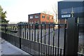
Entrance to Mace Buildings
These fine steel gates protect the entrance to a light industrial unit off the lane from Hunningham Hill to Snowford Bridge.
Image: © David P Howard
Taken: 13 Nov 2011
0.17 miles