IMAGES TAKEN NEAR TO
Offchurch Bury, LEAMINGTON SPA, CV33 9AR
Introduction
This page details the photographs taken nearby to Offchurch Bury, CV33 9AR by members of the Geograph project.
The Geograph project started in 2005 with the aim of publishing, organising and preserving representative images for every square kilometre of Great Britain, Ireland and the Isle of Man.

There are currently over 7.5m images from over14,400 individuals and you can help contribute to the project by visiting https://www.geograph.org.uk
Image Map (Loading...)


Getting Data...Please wait
Leaflet Map data © OpenStreetMap
Images are licensed for reuse under creativecommons.org/licenses/by-sa/2.0
Notes
- Clicking on the map will re-center to the selected point.
- The higher the marker number, the further away the image location is from the centre of the postcode.
Image Listing (5 Images Found)
Images are licensed for reuse under creativecommons.org/licenses/by-sa/2.0
Image
Details
Distance
1
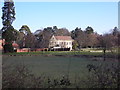
Offchurch Bury
View of the Manor House from across the River Leam
Image: © AJD
Taken: Unknown
0.01 miles
2
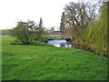
Weir at Offchurch Bury
The River Leam splits into two around an island at this point and the river upstream and on the northern side of the island is impounded by this weir.
Image: © David Stowell
Taken: 21 Apr 2005
0.11 miles
3
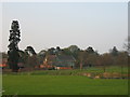
Offchurch Bury
Seen across the River Leam from the public footpath to Redhouse farm. This manor house was originally built in the 17th century, however most of the current house was constructed in the 19th century. It is privately owned and not open to the general public.
Image: © David Stowell
Taken: 21 Apr 2005
0.15 miles
4
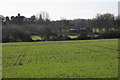
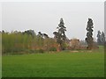
Partly-derelict farm buildings near Offchurch Bury
The River Leam is out of sight below the near hedgerow. Exotic conifers, left, lie to the east of Offchurch Bury.
Image: © Robin Stott
Taken: 30 Jan 2010
0.23 miles
5
Offchurch Bury
Seen from the public footpath in the South West corner of the square.
Image: © David Stowell
Taken: 21 Apr 2005
0.25 miles