IMAGES TAKEN NEAR TO
White Lias Way, CV33 8AE
Introduction
This page details the photographs taken nearby to White Lias Way, CV33 8AE by members of the Geograph project.
The Geograph project started in 2005 with the aim of publishing, organising and preserving representative images for every square kilometre of Great Britain, Ireland and the Isle of Man.

There are currently over 7.5m images from over14,400 individuals and you can help contribute to the project by visiting https://www.geograph.org.uk
Image Map
Images are licensed for reuse under creativecommons.org/licenses/by-sa/2.0
Notes
- Clicking on the map will re-center to the selected point.
- The higher the marker number, the further away the image location is from the centre of the postcode.
Image Listing (4 Images Found)
Images are licensed for reuse under creativecommons.org/licenses/by-sa/2.0
Image
Details
Distance
1
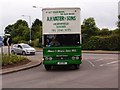
Vater Removals
A Bedford pantechnicon negotiating the roundabout near the Heritage Motor Museum.
Image: © Michael Trolove
Taken: 15 Jun 2014
0.17 miles
2
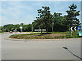
Roundabout At Lighthorne Heath
Situated at the access road to the Gaydon vehicle proving grounds.
Image: © Michael Trolove
Taken: 8 Jun 2008
0.18 miles
4
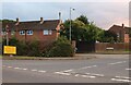
Southam Crescent, Lighthorne Heath
At the junction of Banbury Road
Image: © David Howard
Taken: 1 Aug 2021
0.22 miles