IMAGES TAKEN NEAR TO
Newnham Road, LEAMINGTON SPA, CV32 7SW
Introduction
This page details the photographs taken nearby to Newnham Road, CV32 7SW by members of the Geograph project.
The Geograph project started in 2005 with the aim of publishing, organising and preserving representative images for every square kilometre of Great Britain, Ireland and the Isle of Man.

There are currently over 7.5m images from over14,400 individuals and you can help contribute to the project by visiting https://www.geograph.org.uk
Image Map
Images are licensed for reuse under creativecommons.org/licenses/by-sa/2.0
Notes
- Clicking on the map will re-center to the selected point.
- The higher the marker number, the further away the image location is from the centre of the postcode.
Image Listing (42 Images Found)
Images are licensed for reuse under creativecommons.org/licenses/by-sa/2.0
Image
Details
Distance
1
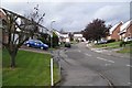
Redcar Close, Lillington, Leamington Spa
A small estate whose roads are named after racecourses.
Image: © Robin Stott
Taken: 22 Oct 2009
0.05 miles
2
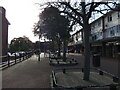
Crown Way shops, Lillington, looking towards Crown Way
This is the upper part of the shopping precinct, to the north-west, looking south-west towards the three-storey blocks of flats on the other side of Crown Way. The shopping centre opened in 1957.
Image: © A J Paxton
Taken: 27 Oct 2012
0.08 miles
3
Crown Way shops, Lillington, seen from across Crown Way
This is the upper part of the shopping precinct. Facing onto Crown Way, behind and to the left of the 'Balti Chef', is the post office (which once included the premises that are now 'Balti Chef'). Beyond and to the left of the post office is the Coral betting shop, which was once a branch of Barclays Bank. The shops, which have flats over them, first opened in 1957 as part of a newly-built estate of council housing.
Image: © A J Paxton
Taken: 27 Oct 2012
0.09 miles
4
Crown Way shops, Lillington
The village of Lillington developed into a suburb of Leamington Spa from the 1930s onwards, with a large estate of council housing being built here in the 1950s. The Crown Way shopping centre opened in 1957 and remains the main retail area of Lillington, though it now has competition from a nearby small supermarket. http://lillingtonhistory.org/web2_documents/newsletters/2015springNewsletter.pdf
Image: © A J Paxton
Taken: 27 Oct 2012
0.10 miles
5
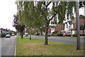
Cubbington Road, Lillington, Leamington Spa
Looking towards Leamington and the junction with Highland Road.
Image: © Robin Stott
Taken: 22 Oct 2009
0.12 miles
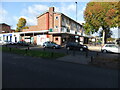
6
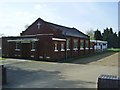
Lillington Free Church Hall
Next to the church on Cubbington Road.
Image: © Ian Rob
Taken: 9 Apr 2011
0.13 miles
7
Lillington Free Church
United Reformed Church on Cubbington Road.
Image: © Ian Rob
Taken: 9 Apr 2011
0.13 miles
8

Cubbington Road, Lillington, Leamington Spa
Behind the trees is the Lillington Free Church. The premises on the right of the picture can be seen fully in Image
Image: © Robin Stott
Taken: 22 Oct 2009
0.13 miles
9
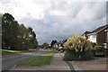
Valley Road, Lillington, Leamington Spa
The park is on the left. The catholic church and the library are beyond the trees.
Image: © Robin Stott
Taken: 22 Oct 2009
0.13 miles
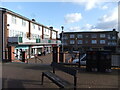
10
Lillington-Tesco Express
Formerly the Walnut Tree Public House on the corner of Crown Way.Image
Image: © Ian Rob
Taken: 9 Apr 2011
0.13 miles