IMAGES TAKEN NEAR TO
Cubbington Road, LEAMINGTON SPA, CV32 7AQ
Introduction
This page details the photographs taken nearby to Cubbington Road, CV32 7AQ by members of the Geograph project.
The Geograph project started in 2005 with the aim of publishing, organising and preserving representative images for every square kilometre of Great Britain, Ireland and the Isle of Man.

There are currently over 7.5m images from over14,400 individuals and you can help contribute to the project by visiting https://www.geograph.org.uk
Image Map (Loading...)


Getting Data...Please wait
Leaflet Map data © OpenStreetMap
Images are licensed for reuse under creativecommons.org/licenses/by-sa/2.0
Notes
- Clicking on the map will re-center to the selected point.
- The higher the marker number, the further away the image location is from the centre of the postcode.
Image Listing (59 Images Found)
Images are licensed for reuse under creativecommons.org/licenses/by-sa/2.0
Image
Details
Distance
1
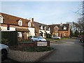
Former Lillington Infant School
Now a des-res development known as Old School Mews, these buildings where formerly the Lillington Infant School before the school moved to new premises nearby in the 1970s. The current OS map however still shows them as a school - another OS "easter egg" perhaps?
Image: © David Stowell
Taken: 16 Mar 2009
0.04 miles
2
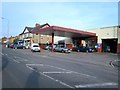
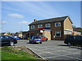
Garage and shops in Lillington
The garage survives as a locally run car maintenance and repair business, although it ceased to sell petrol some years ago due to competition from supermarkets. A similar fate could await the butchers' and general provisions shops to the left of the picture if controversial proposals to replace Image public house nearby with another supermarket are realised.
Image: © David Stowell
Taken: 16 Mar 2009
0.04 miles
3
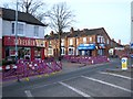
Shops at the Lime Avenue Junction
An off-licence and an "open all hours" general stores at the junction of Lime Avenue are two of the businesses potentially threatened by the proposal to replace Image public house opposite with a new supermarket.
Image: © David Stowell
Taken: 16 Mar 2009
0.04 miles
4
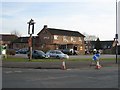
The Walnut Tree
This 1950s built pub at the corner of Crown Way and Lillington Road is currently under threat of takeover, demolition and replacement by yet another supermarket. This controversial proposal is strongly opposed by the locals and the community shops surrounding the site.
Image: © David Stowell
Taken: 16 Mar 2009
0.04 miles
5
Lillington-Tesco Express
Formerly the Walnut Tree Public House on the corner of Crown Way.Image
Image: © Ian Rob
Taken: 9 Apr 2011
0.04 miles
6

Cubbington Road, Lillington, Leamington Spa
Behind the trees is the Lillington Free Church. The premises on the right of the picture can be seen fully in Image
Image: © Robin Stott
Taken: 22 Oct 2009
0.05 miles
7
Lillington Free Church
United Reformed Church on Cubbington Road.
Image: © Ian Rob
Taken: 9 Apr 2011
0.05 miles
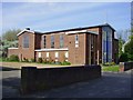
8
Lillington Free Church Hall
Next to the church on Cubbington Road.
Image: © Ian Rob
Taken: 9 Apr 2011
0.05 miles
9
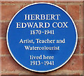
Leamington Spa: Blue Plaque - 7 Manor Road, Lillington
Local Blue Plaque commemorating Herbert Edward Cox the prolific artist, illustrator and teacher
More details of him and his work can be found here
http://www.leamingtonhistory.co.uk/herbert-edward-cox-artist-1870-1941/
Image: © 360Libre
Taken: 7 Mar 2018
0.05 miles
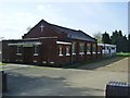
10
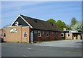
Lillington Social Club
Social Club in Lime Avenue.
Image: © Ian Rob
Taken: 9 Apr 2011
0.05 miles