IMAGES TAKEN NEAR TO
Westgrove Terrace, LEAMINGTON SPA, CV32 6EA
Introduction
This page details the photographs taken nearby to Westgrove Terrace, CV32 6EA by members of the Geograph project.
The Geograph project started in 2005 with the aim of publishing, organising and preserving representative images for every square kilometre of Great Britain, Ireland and the Isle of Man.

There are currently over 7.5m images from over14,400 individuals and you can help contribute to the project by visiting https://www.geograph.org.uk
Image Map (Loading...)


Getting Data...Please wait
Leaflet Map data © OpenStreetMap
Images are licensed for reuse under creativecommons.org/licenses/by-sa/2.0
Notes
- Clicking on the map will re-center to the selected point.
- The higher the marker number, the further away the image location is from the centre of the postcode.
Image Listing (166 Images Found)
Images are licensed for reuse under creativecommons.org/licenses/by-sa/2.0
Image
Details
Distance
1
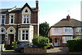
Rugby Road, Leamington Spa
Leamington abounds in abrupt juxtapositions of houses of different ages and types. Note both front gardens paved over for parking, and the replacement concrete roof tiles with rooflights on the Victorian house.
Image: © Robin Stott
Taken: 29 Mar 2009
0.01 miles
2
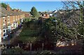
Rear gardens, Milverton, Royal Leamington Spa
On the left, small private gardens are across a common footpath access to their corresponding front doors, an unusual arrangement in the area. The rear of this terrace faces Rugby Road. The common access is thought to be off the footpath in the foreground, which runs between Rugby Road and Warwick New Road at the foot of the railway embankment; in the past it may have related to Milverton station, long gone. In shadow on the right of the photo are properties in unadopted Conway Road and the rear of villas in Warwick New Road.
Image: © Robin Stott
Taken: 25 Nov 2021
0.01 miles
3
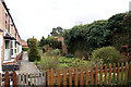
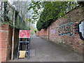
Over the wall
Westgrove Terrace in Leamington Spa is hidden away down a pedestrian walkway running parallel to the railway line. The houses are Victorian and their gardens look onto the high brick garden walls of the large villas fronting onto Warwick New Road.
Image: © Colin Craig
Taken: 30 Mar 2009
0.02 miles
4
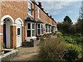
Westgrove Terrace, Milverton, Royal Leamington Spa
It is believed that these houses were built for railway workers when the branch line from Rugby to Leamington was doubled in the early 1880s, and Warwick (Milverton) station was built on the embankment behind the camera. The backs of these houses face Rugby Road.
Image: © Robin Stott
Taken: 16 Apr 2022
0.02 miles
5
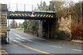
Looking west at the railway bridge over Rugby Road
Image: © Andy F
Taken: 18 Jan 2010
0.02 miles
6
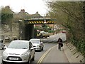
Wise woman rides bike on footway, Rugby Road, Leamington
Rugby Road is not a good place to be on a bike, especially under this railway bridge. It carries the line between Leamington and Coventry. On the right is The Spinney.
Image: © Robin Stott
Taken: 19 Mar 2013
0.03 miles
7
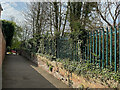
Footpath to Warwick New Road from Rugby Road, Royal Leamington Spa
Image: © Robin Stott
Taken: 16 Apr 2022
0.03 miles
8
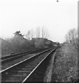
Warwick (Milverton) Station remains
Site of station on outskirts of Leamington Spa and Warwick. Notice at this point the track is now double-track, as it approaches Leamington Spa.
See http://www.warwickshirerailways.com/lms/warwickmilverton_station.htm for history, and Image
Image: © Michael Westley
Taken: Unknown
0.03 miles
9
Footpath to Rugby Road from Warwick New Road, Royal Leamington Spa
The path was closed at the Rugby Road end while the railway bridge was replaced at Easter 2022. The path was associated with the Warwick (Milverton) station built between the two roads in the 1880s; it also gives access to houses originally built for railway workers, Westgrove Terrace Image
Image: © Robin Stott
Taken: 16 Apr 2022
0.04 miles
10
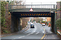
Looking east at the railway bridge over Rugby Road
Image: © Andy F
Taken: 18 Jan 2010
0.04 miles