IMAGES TAKEN NEAR TO
Rugby Road, LEAMINGTON SPA, CV32 6DF
Introduction
This page details the photographs taken nearby to Rugby Road, CV32 6DF by members of the Geograph project.
The Geograph project started in 2005 with the aim of publishing, organising and preserving representative images for every square kilometre of Great Britain, Ireland and the Isle of Man.

There are currently over 7.5m images from over14,400 individuals and you can help contribute to the project by visiting https://www.geograph.org.uk
Image Map
Images are licensed for reuse under creativecommons.org/licenses/by-sa/2.0
Notes
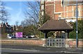
- Clicking on the map will re-center to the selected point.
- The higher the marker number, the further away the image location is from the centre of the postcode.
Image Listing (238 Images Found)
Images are licensed for reuse under creativecommons.org/licenses/by-sa/2.0
Image
Details
Distance
1
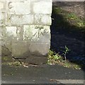
Bench mark, opposite 61 Rugby Road
See http://www.geograph.org.uk/photo/5302327 for location.
Image: © Alan Murray-Rust
Taken: 4 Mar 2017
0.01 miles
2
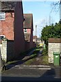
Lane at the back of Gaveston Road
There is a bench mark http://www.geograph.org.uk/photo/5302324 on the corner of the stone wall to the left.
Image: © Alan Murray-Rust
Taken: 4 Mar 2017
0.03 miles
3
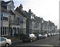
Albany Terrace
A between the wars development with some interesting porches, caught reflecting the winter sun.
Image: © David Stowell
Taken: 10 Dec 2005
0.03 miles
4
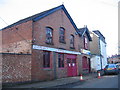
Workshop on Milverton Crescent West
The sidestreets of Leamington Spa used to contain many small workshops and businesses, often housed in adapted stables and coach houses. This example has just been vacated in will no doubt be redeveloped for residential uses.
Image: © David Stowell
Taken: 10 Dec 2005
0.03 miles
5
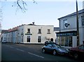
Local Shops
The junction of Union Road and Rugby Road. These two buildings would have been the local pub (on the left) and corner shop (on the right). Whilst they continue as retail premises they are now a Fireplace shop and a Motorcyclist's Accessories shop respectively.
Image: © David Stowell
Taken: 10 Dec 2005
0.03 miles
6
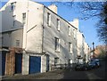
Strathern Road
The curving road serves the rear of Milverton Crescent West, the smallest of Leamington's crescents. The front is hidden away in private gardens.
Image: © David Stowell
Taken: 10 Dec 2005
0.03 miles
7
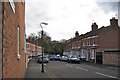
Northern half of Strathearn Road
Seen from Rugby Road. The earlier, southern half is very different Image
Image: © Robin Stott
Taken: 23 Oct 2009
0.03 miles
8
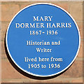
Leamington Spa: Blue Plaque - 16 Gaveston Road
Local Blue Plaque commemorating Mary Dormer Harris the multi talented writer and historian who lived here from 1905.
More details of her and her work can be found here
http://www.leamingtonhistory.co.uk/mary-dormer-harris-1867-1936/
Image: © 360Libre
Taken: 8 Mar 2018
0.05 miles
9
Lych gate and churchyard wall, St Mark's Church
The wall dates from the construction of the church in 1879, the lychgate being a 20th century addition in memory of Lieut. Gen. Sir John Lindesay Keir K.G.B. churchwarden of the church. Listed Grade II.
Image: © Alan Murray-Rust
Taken: 4 Mar 2017
0.05 miles
10
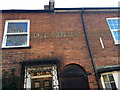
Old painted streetname, 75 Rugby Road, Milverton, Leamington
Originally painted black on white on brickwork, it reads: Bertie Terrace Rugby Road. There is another Bertie Terrace in Warwick Place (originally Bertie Road) Image They were built at the behest of landowner Bertie Bertie Greatheed of Guy's Cliffe.
Image: © Robin Stott
Taken: 20 Jan 2017
0.05 miles