IMAGES TAKEN NEAR TO
Rock Mill Lane, LEAMINGTON SPA, CV32 6AZ
Introduction
This page details the photographs taken nearby to Rock Mill Lane, CV32 6AZ by members of the Geograph project.
The Geograph project started in 2005 with the aim of publishing, organising and preserving representative images for every square kilometre of Great Britain, Ireland and the Isle of Man.

There are currently over 7.5m images from over14,400 individuals and you can help contribute to the project by visiting https://www.geograph.org.uk
Image Map (Loading...)


Getting Data...Please wait
Leaflet Map data © OpenStreetMap
Images are licensed for reuse under creativecommons.org/licenses/by-sa/2.0
Notes
- Clicking on the map will re-center to the selected point.
- The higher the marker number, the further away the image location is from the centre of the postcode.
Image Listing (206 Images Found)
Images are licensed for reuse under creativecommons.org/licenses/by-sa/2.0
Image
Details
Distance
2
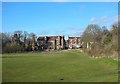
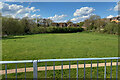
A park in the making, Potterton?s sports ground, Royal Leamington Spa
Pottertons, the people who made boilers, had a works and offices by the River Avon in Warwick. The site, behind the camera, has been redeveloped as flats: see Image from 2009. The staff sportsground across the river in Leamington had a football pitch and a bowling green. Presumably as a condition of planning consent, a public open space is being created. Here is the area to the north of Sir Anthony Eden Way, with a view to Rock Mill and houses in Rock Mill Lane, overlooked by the Riversleigh Road estate off Old Milverton Road. Photographed at about 13:30.
Image: © Robin Stott
Taken: 25 Dec 2018
0.03 miles
3

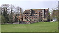
Rock Mill
In the 1790s there was a water powered cotton mill on this site beside the Avon in Milverton. This was subsequently converted to the production of flour and, to overcome the limitations of variable and limited flows steam power was subsequently added, hence the chimney to the left on the trees. After a period of near dereliction thankfully this historic structure survives, albeit converted into upmarket flats.
Image: © David Stowell
Taken: 18 Mar 2009
0.03 miles
5
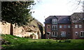
'The Stables', Rock Mill Lane, Leamington Spa
Upmarket apartment blocks have been built in the former sandstone quarry upstream from Rock Mill.
Image: © Robin Stott
Taken: 2 Apr 2009
0.04 miles
6

Former quarry by the River Avon above Rock Mill, Leamington Spa
Image: © Robin Stott
Taken: 2 Apr 2009
0.04 miles
7
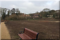
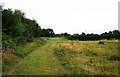
Open space by Rockmill Lane, Royal Leamington Spa
Formerly a sports field associated with the Potterton works across the river. In the background are the Rock Mill (disused) and Rock Mill House. The backs of houses in Quarry Street are seen at upper right. The view is from Sir Anthony Eden Way. Eden, a Conservative, was MP for Warwick and Leamington from 1923 to 1957.
Image: © Robin Stott
Taken: 15 Apr 2022
0.06 miles
8
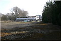
Field adjacent to Sir Anthony Eden Way, Royal Leamington Spa
Sir Anthony Eden Way is in the far distance. The field seems to be mainly used by dog walkers at the present time.
Image: © P L Chadwick
Taken: 27 Jul 2015
0.08 miles
9
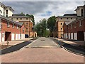
Formal gesture, Waterfront development, Portobello, Warwick
Image: © Robin Stott
Taken: 20 May 2019
0.08 miles
10
Undercrofts for FOGs, The Waterfront, Warwick
Image: © Robin Stott
Taken: 20 Mar 2009
0.09 miles