IMAGES TAKEN NEAR TO
Campion Road, LEAMINGTON SPA, CV32 5XG
Introduction
This page details the photographs taken nearby to Campion Road, CV32 5XG by members of the Geograph project.
The Geograph project started in 2005 with the aim of publishing, organising and preserving representative images for every square kilometre of Great Britain, Ireland and the Isle of Man.

There are currently over 7.5m images from over14,400 individuals and you can help contribute to the project by visiting https://www.geograph.org.uk
Image Map
Images are licensed for reuse under creativecommons.org/licenses/by-sa/2.0
Notes
- Clicking on the map will re-center to the selected point.
- The higher the marker number, the further away the image location is from the centre of the postcode.
Image Listing (66 Images Found)
Images are licensed for reuse under creativecommons.org/licenses/by-sa/2.0
Image
Details
Distance
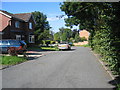
1
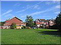
Pleasant Way
Part of the 1970s development around the site of the former claypits and works of the Leamington Brick Company in the middle of this square.
Image: © David Stowell
Taken: 28 Aug 2005
0.07 miles
2
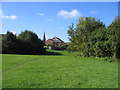
Site of Leamington Brick Company
The claypits and works of the Leamington Brick Company occupied the SW corner of this square and provided the material for much of the construction of Leamington Spa until the middle of the last century. The pits have long since been filled in and grassed over to form an open space. This picture is looking SW with the spire of St Paul's visible on Leicester St. The area around the edge of the pits was developed for housing in the 1960s and 70s.
Image: © David Stowell
Taken: 28 Aug 2005
0.07 miles
3
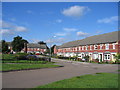
Chestnut Square, Royal Leamington Spa
This development occupies land that for many years was used for allotments. The house design attempts to match many of the older terraces in the town. Unfortunately however the architect failed to replicate the vertical proportions of the buildings with the result that these properties look like they have been partially squashed by a giant foot!
Image: © David Stowell
Taken: 28 Aug 2005
0.07 miles
4
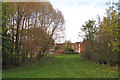
Greenspace off Kiln Close, Leamington
Looking towards the end of Jasmine Grove. 'Kiln' is a reminder that this was the site of the Leamington brickworks.
Image: © Robin Stott
Taken: 27 Oct 2009
0.12 miles
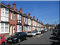
5
Granville Street, Royal Leamington Spa
Image: © Alex McGregor
Taken: 18 Apr 2011
0.12 miles
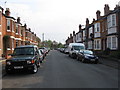
6
Granville Street
One of several similarly styled streets in this area built between the late 1890's and early 1900's and named after local worthies of the time. Compare with Image taken from the spot albeit at significantly different dates and temperatures!
Image: © David Stowell
Taken: 21 Aug 2005
0.13 miles
7
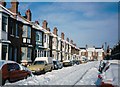
Granville Street in the snow
Following a particularly heavy snowfall in December 1990. Compare with Image taken from the same spot on a somewhat warmer day, about 15 years later
Image: © David Stowell
Taken: Unknown
0.13 miles
8
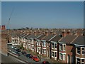
Lillington
A view Northwards across rooftops towards Lillington. The flag pole on the top of St Mary's church is just visible above the trees in the left-centre of the picture
Image: © David Stowell
Taken: 8 Apr 2000
0.13 miles
9
Jasmine Grove
The claypits and works of the Leamington Brick Company occupied the SW corner of this square and provided the material for much of the construction of Leamington Spa until the middle of the last century. The pits have long since been filled in and the area around the edge of the pits developed for housing in the 1960s and 70s. Jasmine Grove, hidden away behind Campion Road is part of that development.
Image: © David Stowell
Taken: 28 Aug 2005
0.13 miles
10
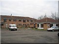
Charles Watson Court
The other one of the two adjacent retirement home and sheltered accommodation complex in this area in the north of this square. This one, the more recent of the two, is on Shuckburgh Drive
Image: © David Stowell
Taken: 2 Jan 2006
0.15 miles