IMAGES TAKEN NEAR TO
St. Pauls Square, LEAMINGTON SPA, CV32 4TX
Introduction
This page details the photographs taken nearby to St. Pauls Square, CV32 4TX by members of the Geograph project.
The Geograph project started in 2005 with the aim of publishing, organising and preserving representative images for every square kilometre of Great Britain, Ireland and the Isle of Man.

There are currently over 7.5m images from over14,400 individuals and you can help contribute to the project by visiting https://www.geograph.org.uk
Image Map
Images are licensed for reuse under creativecommons.org/licenses/by-sa/2.0
Notes
- Clicking on the map will re-center to the selected point.
- The higher the marker number, the further away the image location is from the centre of the postcode.
Image Listing (226 Images Found)
Images are licensed for reuse under creativecommons.org/licenses/by-sa/2.0
Image
Details
Distance
1
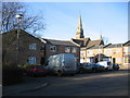
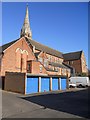
OS Easter Egg
According to the current OS 1:25,000 map there is a place of worship where these vehicles are parked at the junction of Vincent Street and Queen Street. This looks very much like an OS "Easter Egg", that is a deliberately introduced mistake to provide a copyright watermarking. Either that or it is the newly formed church of the White Van!
Image: © David Stowell
Taken: 17 Dec 2005
0.03 miles
2
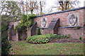
Leamington coats of arms in a wall
These coats of arms are incorporated into the surviving wall of a former National school built in 1895 in Leicester Street. It now within the site of the Newbold Centre, home to the county council's Warwickshire Learning Disability Board.
Image: © Robin Stott
Taken: 27 Oct 2009
0.03 miles
3
St Paul's - no, not that one
St Paul's church in Leamington Spa.
Image: © Colin Craig
Taken: 23 Apr 2009
0.04 miles
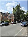
4
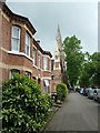
The south side of Leicester Street
Looking towards St Paul's church.
Image: © Christine Johnstone
Taken: 18 May 2019
0.04 miles
5
Leamington Spa-Saint Paul's Church
An alternative view from Saint Paul's Square.
Image: © Ian Rob
Taken: 14 Jan 2012
0.04 miles
6
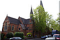
St Paul's Church, Royal Leamington Spa
St Paul’s Church was built between 1873 and 1874. It is a Grade II listed building (English Heritage Building ID: 481745 http://www.britishlistedbuildings.co.uk/en-481745-church-of-st-paul-royal-leamington-spa-w British Listed Buildings).
Image: © David Dixon
Taken: 21 Jul 2014
0.04 miles
7
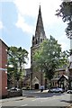
St Paul's Church, Royal Leamington Spa
St Paul’s Church was built between 1873 and 1874. It is a Grade II listed building (English Heritage Building ID: 481745 http://www.britishlistedbuildings.co.uk/en-481745-church-of-st-paul-royal-leamington-spa-w British Listed Buildings).
Image: © David Dixon
Taken: 21 Jul 2014
0.05 miles
8
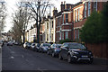
Leicester Street, Leamington Spa
Looking along the western end of Leicester Street towards the junction with Clarendon Street.
Image: © Stephen McKay
Taken: 23 Nov 2013
0.05 miles
9
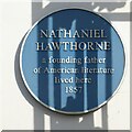
Blue plaque to Nathaniel Hawthorne
Blue plaque to Nathaniel Hawthorne a founding father of American literature who lived on Lansdowne Circus.
Image: © Philip Halling
Taken: 17 Oct 2023
0.05 miles
10
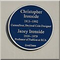
Blue plaque to Christopher and Janey Ironside
Blue plaque to Christopher and Janey Ironside on a house in Lansdowne Circus.
Image: © Philip Halling
Taken: 17 Oct 2023
0.05 miles