IMAGES TAKEN NEAR TO
Newbold Street, LEAMINGTON SPA, CV32 4HN
Introduction
This page details the photographs taken nearby to Newbold Street, CV32 4HN by members of the Geograph project.
The Geograph project started in 2005 with the aim of publishing, organising and preserving representative images for every square kilometre of Great Britain, Ireland and the Isle of Man.

There are currently over 7.5m images from over14,400 individuals and you can help contribute to the project by visiting https://www.geograph.org.uk
Image Map
Images are licensed for reuse under creativecommons.org/licenses/by-sa/2.0
Notes
- Clicking on the map will re-center to the selected point.
- The higher the marker number, the further away the image location is from the centre of the postcode.
Image Listing (1012 Images Found)
Images are licensed for reuse under creativecommons.org/licenses/by-sa/2.0
Image
Details
Distance
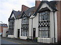
1
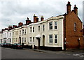
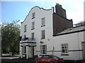
East side of Newbold Street, Royal Leamington Spa
Looking towards Hamilton Terrace from the corner of Rosefield Street.
Image: © Jaggery
Taken: 19 Apr 2015
0.01 miles
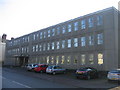
2
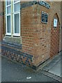
Leamington, Chapel Court
The building, formerly a warehouse, now the premises of Burgis & Bullock, accounts. There is an Ordnance Survey cut mark benchmark on the building which is described on the Bench Mark Database at http://www.bench-marks.org.uk/bm34641.
Image: © Roger Templeman
Taken: 10 Jun 2010
0.02 miles
3
Gone ? a handsome walnut tree, Newbold Street, Royal Leamington Spa
Trees don't live forever, especially in the built environment.
Image: © Robin Stott
Taken: 30 Apr 2015
0.03 miles
4
Rosefield Street, Royal Leamington Spa
Looking NE from the corner of Newbold Street.
Image: © Jaggery
Taken: 19 Apr 2015
0.03 miles
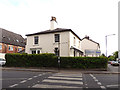
5
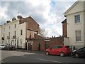
Leamington-The Newbold
Public House on Newbold Street.
Image: © Ian Rob
Taken: 2 May 2011
0.03 miles
6
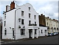
The Drawing Board, Royal Leamington Spa
Pub on the corner of Newbold Street and Rosefield Street viewed in mid April 2015.
Recently renamed the Drawing Board, formerly the Regency Arms and before that, the Newbold. http://www.geograph.org.uk/photo/2403170
Image: © Jaggery
Taken: 19 Apr 2015
0.03 miles
7
Myton House (Handelsbanken), Holly Walk, Leamington Spa
Listed grade II (list entry 1381311) as "Myton House", built c.1833 as a private house and now a branch of a Swedish bank. A zebra crossing is in the foreground.
Image: © Stephen Craven
Taken: 16 Jul 2018
0.03 miles
8
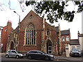
Former Holly Walk Chapel, Leamington Spa
Built in 1849 to the designs of D G Squirhill as a Congregational chapel, from 1896 to 1947 it was used an Anglican proprietary chapel knows as St Luke's. Now converted, probably to residential use.
Image: © Stephen Craven
Taken: 16 Jul 2018
0.04 miles
9
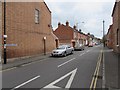
Cottages, William Street, Royal Leamington Spa
This area of Leamington grew considerably from about 1820 to the 1850s with a wide variety of architectural styles from Regency to simple terraces. These three in William Street, named as cottages, are an example of the many unique styles.
Image: © David Stowell
Taken: 10 Aug 2005
0.04 miles
10
Brandon Parade
This stark building houses the Leamington Spa Job Centre.
Image: © David Stowell
Taken: 28 Jan 2006
0.04 miles