IMAGES TAKEN NEAR TO
Bath Place, LEAMINGTON SPA, CV31 3RJ
Introduction
This page details the photographs taken nearby to Bath Place, CV31 3RJ by members of the Geograph project.
The Geograph project started in 2005 with the aim of publishing, organising and preserving representative images for every square kilometre of Great Britain, Ireland and the Isle of Man.

There are currently over 7.5m images from over14,400 individuals and you can help contribute to the project by visiting https://www.geograph.org.uk
Image Map
Images are licensed for reuse under creativecommons.org/licenses/by-sa/2.0
Notes
- Clicking on the map will re-center to the selected point.
- The higher the marker number, the further away the image location is from the centre of the postcode.
Image Listing (1360 Images Found)
Images are licensed for reuse under creativecommons.org/licenses/by-sa/2.0
Image
Details
Distance
1
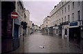
Floods at Bath Street, Royal Leamington Spa
Bath Street complete with the overflowing River Leam during the April 1998 floods. Compare with Image on a drier day.
Image: © David Stowell
Taken: Unknown
0.02 miles
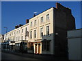
2
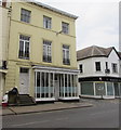
The Beehive, Royal Leamington Spa
Hairdressers at 42 Bath Street on the corner of Abbott Street.
Image: © Jaggery
Taken: 19 Apr 2015
0.02 miles
3
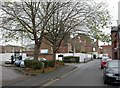
Leamington Spa, former community centre
Bath Place Community Centre, site of a devastating fire in 2009. Many of the activities formerly here have transferred to Image http://www.bathplace.org/restoration.php
Image: © Mike Faherty
Taken: 20 Nov 2010
0.02 miles
4
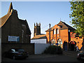
Bath Place from Bath Place car park
The bell tower of All Saints, the parish church and just in this square, draws the eye. On the left is the former Bath Place School, home to Bath Place Community Venture until fire damage occasioned a move to the Old Library in Avenue Road. Hoardings had just been put up prior to partial demolition. The red canopy marks the entrance to the Emperors Chinese restaurant: recommended.
Image: © Robin Stott
Taken: 17 Jun 2010
0.02 miles
5
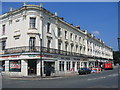
Victoria Terrace, Royal Leamington Spa
The terrace, opposite the Parish Church, was originally built in 1838 and has seen a variety of uses and businesses come and go over the years
Image: © David Stowell
Taken: 9 Jul 2005
0.02 miles
6
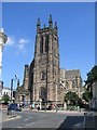
All Saints Parish Church, Royal Leamington Spa
The church actually straddles two squares. This is the west end, showing the tower completed in 1902. The small stone pillar to the right of centre marks the site of Lord Aylesford's Well, Leamington's original spring were spa waters could be "taken free in small quantities from the pump erected outside the building, wine bottles filled for 1d each".
The church has its own excellent website at:- http://www.allsaintsleamington.org.uk/ where the choir and organ can be heard.
Image: © David Stowell
Taken: 16 Jul 2005
0.02 miles
7
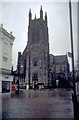
All Saints in the Floods
The Parish Church seen from Avenue Road during the April 1998 floods. Compare with Image
Image: © David Stowell
Taken: Unknown
0.02 miles
8
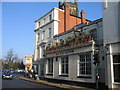
The Jug and Jester
A much extended and often renamed pub at the junction of Bath Street and the Lower Parade.
Image: © David Stowell
Taken: 28 Jan 2006
0.02 miles
9
The Avenue Hotel, Leamington Spa
The Avenue Hotel, in Avenue Road, is amongst the oldest of Leamington's surviving hotels and has now had"Heritage" added to its name in recognition of this fact.
Image: © David Stowell
Taken: 28 Jan 2006
0.02 miles
10
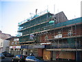
Bath Assembly Hall
This building in Spencer Street was built in 1926 as the Bath Assembly Hall. The date of construction is still visible in the stonework, currently concealed behind the scaffolding. In recent years the building was used as a garage but it is now being renovated.
Image: © David Stowell
Taken: 28 Jan 2006
0.02 miles