IMAGES TAKEN NEAR TO
Avenue Road, LEAMINGTON SPA, CV31 3PE
Introduction
This page details the photographs taken nearby to Avenue Road, CV31 3PE by members of the Geograph project.
The Geograph project started in 2005 with the aim of publishing, organising and preserving representative images for every square kilometre of Great Britain, Ireland and the Isle of Man.

There are currently over 7.5m images from over14,400 individuals and you can help contribute to the project by visiting https://www.geograph.org.uk
Image Map
Images are licensed for reuse under creativecommons.org/licenses/by-sa/2.0
Notes
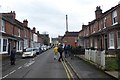
- Clicking on the map will re-center to the selected point.
- The higher the marker number, the further away the image location is from the centre of the postcode.
Image Listing (631 Images Found)
Images are licensed for reuse under creativecommons.org/licenses/by-sa/2.0
Image
Details
Distance
1
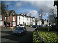
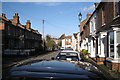
Avenue Road, Royal Leamington Spa
The view is from Park Drive, by the former lodge to Victoria Park. Avenue Road developed west of Adelaide Road in the later 19th century.
Image: © Robin Stott
Taken: 11 Mar 2013
0.01 miles
2
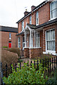
Porch detail, Victoria Street, Leamington Spa
Image: © Jim Osley
Taken: 4 Mar 2017
0.01 miles
3
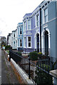
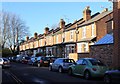
Housing terrace, Avenue Road, Leamington Spa
Image: © Jim Osley
Taken: 4 Mar 2017
0.02 miles
4
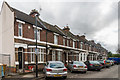
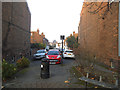
Victoria Road
A cul de sac of 19th Century terraced housing off Victoria Street.
Image: © Ian Capper
Taken: 4 Mar 2017
0.02 miles
5
Victoria Street, Leamington
Together with Victoria Road, left, it forms a compact enclave of terraced housing between Avenue Road, Archery Road and Victoria Park. Built before 1886.
Image: © Robin Stott
Taken: 26 Nov 2009
0.03 miles
6
Victoria Road
View WNW along Victoria Road from its junction with Victoria Street.
Image: © David P Howard
Taken: 2 Jan 2012
0.03 miles
7

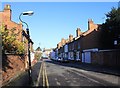
Victoria Street
A road of mainly 19th Century terraced housing.
Image: © Ian Capper
Taken: 4 Mar 2017
0.03 miles
8
South end of Victoria Street, Leamington Spa
It looks to have been a through road originally, but now a dead end.
Image: © Stephen Craven
Taken: 17 Nov 2018
0.03 miles
9
Victoria Street
Looking NNE along Victoria Street towards its junction with Archery Road. The Cricketers Arms can be seen at the end of the street.
Image: © David P Howard
Taken: 2 Jan 2012
0.03 miles
10
Victoria Street
Looking along Victoria Street, a row of terraced houses near Victoria Park.
Image: © DS Pugh
Taken: 4 Mar 2017
0.03 miles